Show the map
Evaluated Track - ITRA
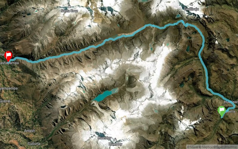
Sierra Andina Mountain Trail 2017 - Santa Cruz 45K


 Inconnu (ND)
 Inconnu (ND)


The famous Santa Cruz Trail passes through the heart of the Cordillera Blanca and is undoubtedly the most popular and scenic route through Huascaran National Park. Typically done as a 4-day point to point hike, it was listed as one of the best hikes in the world by National Geographic, "...a less-crowded alternative to the hordes headed to Machu Picchu on the Inca Trail" and one of the best hidden gems of South America.
This 45km/ 28mi course starts just outside the small village of Vaqueria on the eastern side of the Cordillera Blanca. Climbing just over 1,300m in the first 18km to the top of Punta Union Pass at 4,750m, racers will gain one of the most amazing views in all of Peru. From Punta Union racers will descend down through the stunning Santa Cruz Valley passing many of the icy 5,000 and 6,000m peaks, flowing glaciers and crystal lakes that define the Cordillera Blanca and Huascaran National Park.
Running this route through the High Andes is a truly rewarding experience that you will remember for the rest of your life. Interested yet?
The overall elevation change of the course is roughly 1,875m of gain and 2,620m of loss.
Points of Interest table
| Accum. | Intermediary | |||||||
|---|---|---|---|---|---|---|---|---|
| POI | Description | Alt. | Dist. | D+ | D- | Dist. | D+ | D- |
 Competition organized on 08/12/2017
Trace n°40241
Ascent threshold : 15 m Distance threshold : 30 m Smoothing : Yes Origin of altitudes : MNT SRTM3
Ascent threshold : 15 m Distance threshold : 30 m Smoothing : Yes Origin of altitudes : MNT SRTM3
Crossing
Dominant terrain : Footpath
Max alti. : 4753 m
Avg alti. : 3847 m
Min alti. : 2926 m
Longest ascent : 1100 m
Longest descent : 2040 m
Dominant terrain : Footpath
Max alti. : 4753 m
Avg alti. : 3847 m
Min alti. : 2926 m
Longest ascent : 1100 m
Longest descent : 2040 m
Elevation profile
More tools
Create a new roadbook page
Map and track on your website
Warning ! When you insert a Trace de Trail map on your website, you agree not to hide any element of the module (links to Trail Trail or Trail Connect banner)
Add a realisation
Validate
Add a realisation to share your chrono and describe the conditions that you encountered during you trail running !
Add a comment
Validate
Show the infos
Add a track


