Afficher la carte
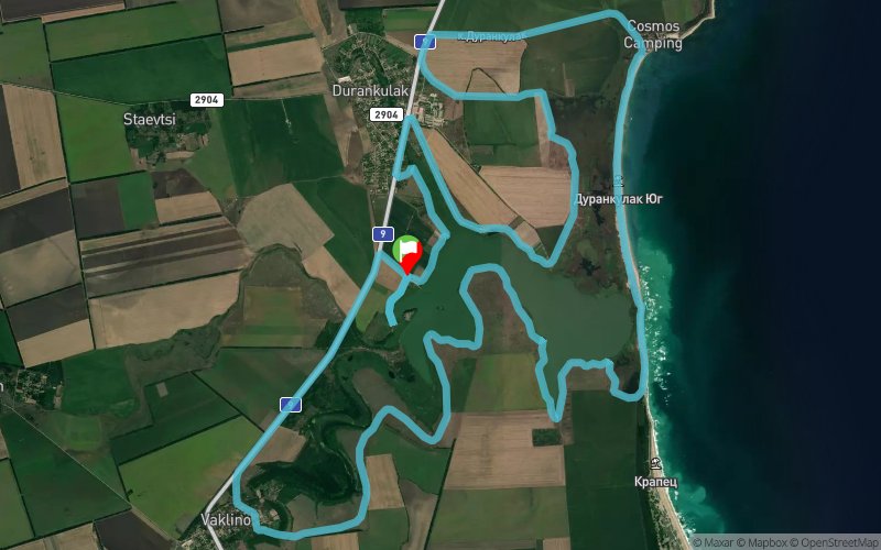
Black Sea Route - Tour of Durankulak Lake


 ?????????? / Durankulak (BG)
???????????? ???????? ?? ???????????? ?????, ???? ?? ???????????? ??????? "??????????? ???". ????????? ?? ??????????? ??? ????????? ??????.
?????????????? ????? ? ???? ???-????????? ? ???-????? ?????????? ?????????? ?????? ???? ? ????????, ? ???????????? ???????? ?? ?????????? ?? ?????? ?? 260 ???? ????? ? ?????????? ?? ????????? ???????? ? ???????. ??????????? ?? ???????????? ??? Via Pontica, ???????? ???? ????????? ???????????? ??????? ?? ??????? ? ??????? ?? ?????? ???????? ?????? ?????.
?? ???????? ?????? – ??????????, ???????? ???? ????????????? ???? „???????????? ????“ ? „???????? ????“, ?? ?????? ??????? ???????????????? ????? ?? ??????? ? ????????. ?? ???? ??????? ?? ?????????? ? ???????????? ??????? ????? ?? ???????:
- ??????? ?? ????????? (??? 100 ???? ??. ??.),
- ???????? ?? ??????? ???-?????? ????????, ????????, ?????????? ? ???????????? ????????? ? ?????? (54 ??? ??. ??.),
- ??????? ??????? ??????? ? ?????? (51 ??? ??. ??.),
- ???-??????? ?????????? ????? ? ????? (50 ??? ??. ??.),
- ????? ??????? ?? ??????? ????? ? ????????? ??????? (50 – 48 ??? ??. ??.) ??????????? ?? ???????????????? ???????? ??????????????,
- ???-??????? ????? ?? ???????-???????? ???????? (50 – 48 ??? ??. ??.),
- ??? ? ?????????????? ? ???-????? ???? (?????? 55 – 54 ??? ??. ??.), ???????? ????????, ?? ???????? ??? ?? ???????? ???? ??????????, ?? ???????????? ???????? ??????? ?????????.
Tour of Durankulak Lake, part of the Black Sea tourist route. Suitable for cycling or hiking.
Durankulak Lake is one of the most significant and preserved coastal wetlands in Bulgaria, with an international significance for the conservation of more than 260 species of rare and endangered plants and animals. Located on the Via Pontica migration route, the wetland provides favorable conditions for eating and resting a number of migratory bird species.
On the Big Island - Durankulak, known among the specialists "European Troy" and "Lake City", is the first outdoor open-air museum in Bulgaria. This sign of world and European history reveals:
- findings from the Paleolithic (over 100 centuries BC),
- the settlements of the first most ancient cultural, rural, agricultural and craft work in Europe (54th century BC),
- the first stone constructions in Europe (51st Century BC),
- the oldest processed gold in the world (50th century BC),
- the beginning of the written signs in human history (50-48 BC), predecessor of the prehistoric Danube prototype,
- the earliest forms of exchange-rate (50-48 BC),
- here is the oldest phase (beginning 55-54 BC), called Blatnica, the ancient name of today's village of Durankulak, the European neolithic culture Hamandjia.
Table des passages
| Cumul | Intermédiaire | |||||||
|---|---|---|---|---|---|---|---|---|
| Passage | Description | Alt. | Dist. | D+ | D- | Dist. | D+ | D- |
Trace n°78053
Seuil de dénivelé : 20 m Seuil de distance : 30 m Lissage : Non Origine des altitudes : MNT Aster GDEM
Seuil de dénivelé : 20 m Seuil de distance : 30 m Lissage : Non Origine des altitudes : MNT Aster GDEM
Boucle
Terrain dominant : Chemin
Alti. max. : 61 m
Alti. moyenne : 16 m
Alti. min. : 0 m
+ longue montée : 50 m
+ longue descente : 50 m
Parcours effectué par l'auteur : Oui
Terrain dominant : Chemin
Alti. max. : 61 m
Alti. moyenne : 16 m
Alti. min. : 0 m
+ longue montée : 50 m
+ longue descente : 50 m
Parcours effectué par l'auteur : Oui
Profils altimétriques
Plus d'outils
Créer une page de roadbook
Carte et profil sur votre site web
Attention ! En insérant une carte Trace de Trail sur votre site web, vous vous engagez à ne masquer aucun élément du module (liens vers Trace de Trail ou bannière Trail Connect), que ce soit en utilisant l'iframe ou le widget.
Ajouter une réalisation
Valider
Ajoutez une réalisation pour partager votre chrono et détailler les conditions que vous avez recontrées lors de votre sortie trail !
Ajouter un commentaire
Valider
Afficher les infos
Ajouter une trace


