Show the map
OFFICIAL ROUTE
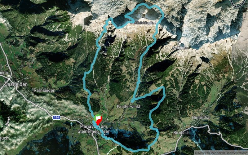
Hochkönigman - Skyrace Original


 Alm (AT)
Winner of the Trailrunning Award and the best Trailrunning Event in Austria. Magic Mountains, Magic show and Magic People. From Easy Trail to Skyrace and public show tih artists and Cross Warrior. Come see and believe!
Points of Interest table
| Accum. | Intermediary | |||||||
|---|---|---|---|---|---|---|---|---|
| POI | Description | Alt. | Dist. | D+ | D- | Dist. | D+ | D- |
 Competition organized on 06/07/2020
Trace n°99643
Ascent threshold : 3 m Distance threshold : 30 m Smoothing : Yes Origin of altitudes : MNT Google
Ascent threshold : 3 m Distance threshold : 30 m Smoothing : Yes Origin of altitudes : MNT Google
Loop
Dominant terrain : Footpath
Max alti. : 2407 m
Avg alti. : 1432 m
Min alti. : 799 m
Longest ascent : 1710 m
Longest descent : 1380 m
Dominant terrain : Footpath
Max alti. : 2407 m
Avg alti. : 1432 m
Min alti. : 799 m
Longest ascent : 1710 m
Longest descent : 1380 m
Elevation profile
More tools
Create a new roadbook page
Map and track on your website
Warning ! When you insert a Trace de Trail map on your website, you agree not to hide any element of the module (links to Trail Trail or Trail Connect banner)
Add a realisation
Validate
Add a realisation to share your chrono and describe the conditions that you encountered during you trail running !
Add a comment
Validate
Show the infos
Add a track


