Show the map
OFFICIAL ROUTE
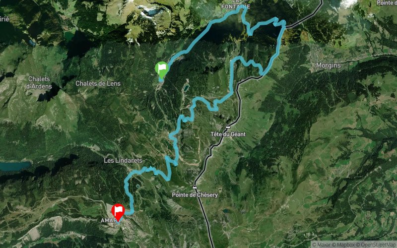
Oürea Trail 2021 - Étape 3 / Oürea Solo 3 - 23 km


23.7 km
1960 m
1420 m
 Morgins (CH)
 Les Crosets (CH)
Date: Monday 26 July 2021, Start: Individual Time Trial, Start time: First athlete at 09:00 hrs
Reckon on 30 to 40’ to get to the start via the chairlifts from Avoriaz.
This stage will showcase part of the Abondance Valley as far as Châtel. On the way back, along the ridge of the Pointe du Midi, you’ll have one foot in France and the other in Switzerland with a view across Morgins. At the end of the stage, you’ll drop down from Rochassons ridge as far as Lindarets via a downhill mountain bike track… thrills and spills guaranteed for the speed freaks!
To get to the start of the time trial, athletes and spectators will take the following chairlifts: Lindarets, Chaux Fleurie, Rochassons and Pierre-Longue. (Free for athletes, included in the Portes du Soleil Multipass for spectators).
Using the latter, spectators will be able to cheer on the athletes at the race start, at Les Chalets de Plaine Dranse at the 18.5km point (by taking the Pierre-Longue chairlift), at the Rochassons ridge at the 20km point (by taking the Rochassons chairlift) and at the foot of the Lindarets chairlift at the 22.5km point.
Points of Interest table
| Accum. | Intermediary | |||||||
|---|---|---|---|---|---|---|---|---|
| POI | Description | Alt. | Dist. | D+ | D- | Dist. | D+ | D- |
 Competition organized on 07/26/2021
Trace n°91547
Ascent threshold : 3 m Distance threshold : 30 m Smoothing : Yes Origin of altitudes : MNT IGN
Ascent threshold : 3 m Distance threshold : 30 m Smoothing : Yes Origin of altitudes : MNT IGN
Crossing
Dominant terrain : Footpath
Max alti. : 2042 m
Avg alti. : 1640 m
Min alti. : 1126 m
Longest ascent : 780 m
Longest descent : 440 m
Dominant terrain : Footpath
Max alti. : 2042 m
Avg alti. : 1640 m
Min alti. : 1126 m
Longest ascent : 780 m
Longest descent : 440 m
Elevation profile
More tools
Create a new roadbook page
Map and track on your website
Warning ! When you insert a Trace de Trail map on your website, you agree not to hide any element of the module (links to Trail Trail or Trail Connect banner)
Add a realisation
Validate
Add a realisation to share your chrono and describe the conditions that you encountered during you trail running !
Add a comment
Validate
Show the infos
Add a track


