Show the map
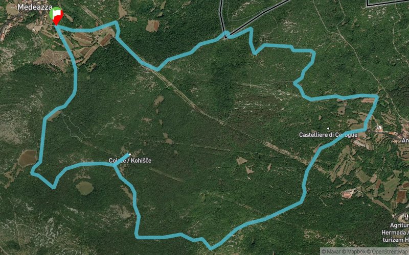
Medeazza - Kohisce - Ceroglie


9.1 km
310 m
310 m
 Villaggio Del Pescatore (IT)
Questo anello di 10 km si articola sulle pendici del Monte Ermada, da cui si gode una vista a 360 gradi sul golfo di Trieste e sulle Prealpi Giulie, fino al Monte Kanin nelle giornate più terse. Un anello dove la vista del mare incontra i monti, esprimendo a pieno la poliedricità del Carso. Tutto il percorso avviene su strada forestale, quindi percorrbile agevolemente anche in mountain bike e con appositi passeggini.
Partenza da Medeazza, nei pressi dell'azieda agricola Pernancih, si rposegue verso Ceroglie, passando per l'Agriturismo Antonic, entrambe tappe dove vale la pena fermarsi per assaggiare i formaggi di del Carso. Da ceroglie si prosegue verso l'antico borgo di Kohisce, punto ideale in cui fermarsi anche a fare un pic nic ed una sosta con vista sul golfo. Da qui si prosegue tornando a Medeazza
Points of Interest table
| Accum. | Intermediary | |||||||
|---|---|---|---|---|---|---|---|---|
| POI | Description | Alt. | Dist. | D+ | D- | Dist. | D+ | D- |
Trace n°89004
Ascent threshold : 3 m Distance threshold : 30 m Smoothing : Yes Origin of altitudes : MNT Aster GDEM
Ascent threshold : 3 m Distance threshold : 30 m Smoothing : Yes Origin of altitudes : MNT Aster GDEM
Loop
Dominant terrain : Path
Max alti. : 311 m
Avg alti. : 194 m
Min alti. : 146 m
Longest ascent : 110 m
Longest descent : 110 m
Route completed by the author : Yes
Dominant terrain : Path
Max alti. : 311 m
Avg alti. : 194 m
Min alti. : 146 m
Longest ascent : 110 m
Longest descent : 110 m
Route completed by the author : Yes
Elevation profile
More tools
Create a new roadbook page
Map and track on your website
Warning ! When you insert a Trace de Trail map on your website, you agree not to hide any element of the module (links to Trail Trail or Trail Connect banner)
Add a realisation
Validate
Add a realisation to share your chrono and describe the conditions that you encountered during you trail running !
Add a comment
Validate
Show the infos
Add a track


