Show the map
Bois de la Perthe - La Maison Brûlée - Mont Aigu
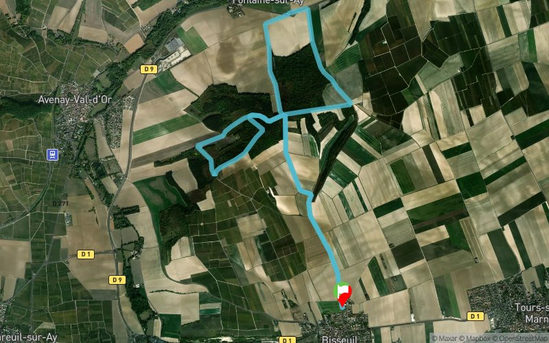


11.6 km
300 m
300 m
 Bisseuil (51)
 Points of Interest table
| Accum. | Intermediary | |||||||
|---|---|---|---|---|---|---|---|---|
| POI | Description | Alt. | Dist. | D+ | D- | Dist. | D+ | D- |
Trace n°82793
Ascent threshold : 3 m Distance threshold : 30 m Smoothing : No Origin of altitudes : MNT Aster GDEM
Ascent threshold : 3 m Distance threshold : 30 m Smoothing : No Origin of altitudes : MNT Aster GDEM
Loop
Dominant terrain : Path
Max alti. : 202 m
Avg alti. : 133 m
Min alti. : 78 m
Longest ascent : 110 m
Longest descent : 130 m
Route completed by the author : No
Dominant terrain : Path
Max alti. : 202 m
Avg alti. : 133 m
Min alti. : 78 m
Longest ascent : 110 m
Longest descent : 130 m
Route completed by the author : No
Elevation profile
More tools
Create a new roadbook page
Map and track on your website
Warning ! When you insert a Trace de Trail map on your website, you agree not to hide any element of the module (links to Trail Trail or Trail Connect banner)
Add a realisation
Validate
Add a realisation to share your chrono and describe the conditions that you encountered during you trail running !
Add a comment
Validate
ptitgrimpeur
07/02/21, 16:32:10
Parcours sympa avec de beau passages, par contre très boueux en cette période donc glissant. Je n'ai pas non plus choisi le bon jour car pleins de chasseurs sur le parcours. Merci pour la découverte de ce parcours que je referai a différente saison.
07/02/21, 16:32:10
Parcours sympa avec de beau passages, par contre très boueux en cette période donc glissant. Je n'ai pas non plus choisi le bon jour car pleins de chasseurs sur le parcours. Merci pour la découverte de ce parcours que je referai a différente saison.
Show the infos
Add a track


