Show the map
Agy - Fimaloz - Tréchard
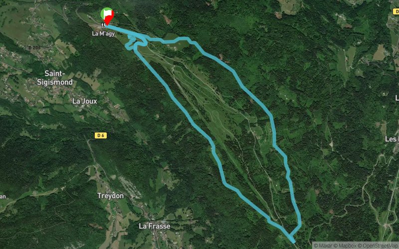


9.4 km
260 m
260 m
 Saint-Sigismond (74)
 Points of Interest table
| Accum. | Intermediary | |||||||
|---|---|---|---|---|---|---|---|---|
| POI | Description | Alt. | Dist. | D+ | D- | Dist. | D+ | D- |
Trace n°79968
Ascent threshold : 3 m Distance threshold : 30 m Smoothing : Yes Origin of altitudes : MNT IGN
Ascent threshold : 3 m Distance threshold : 30 m Smoothing : Yes Origin of altitudes : MNT IGN
Loop
Dominant terrain : Path
Max alti. : 1409 m
Avg alti. : 1327 m
Min alti. : 1241 m
Longest ascent : 90 m
Longest descent : 100 m
Route completed by the author : Yes
Dominant terrain : Path
Max alti. : 1409 m
Avg alti. : 1327 m
Min alti. : 1241 m
Longest ascent : 90 m
Longest descent : 100 m
Route completed by the author : Yes
Elevation profile
More tools
Create a new roadbook page
Map and track on your website
Warning ! When you insert a Trace de Trail map on your website, you agree not to hide any element of the module (links to Trail Trail or Trail Connect banner)
Add a realisation
Validate
Add a realisation to share your chrono and describe the conditions that you encountered during you trail running !
Add a comment
Validate
Olivier - Team Trace de Trail
20/02/19, 09:53:57
Au départ du centre nordique d'Agy. piste piétonne damée régulièrement. suivre balisage piéton. ne pas courir sur les pistes de ski de fond.
20/02/19, 09:53:57
Au départ du centre nordique d'Agy. piste piétonne damée régulièrement. suivre balisage piéton. ne pas courir sur les pistes de ski de fond.
Show the infos
Add a track


