Show the map
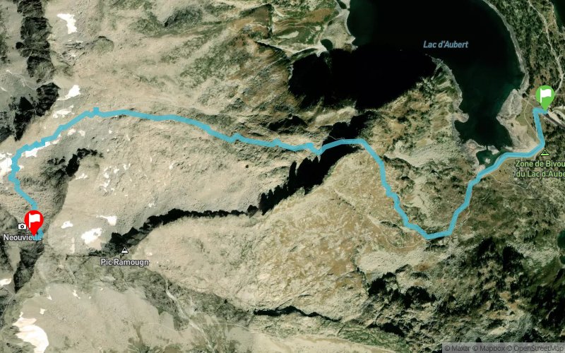
Lac d'Aubert - Pic de Néouvielle


5 km
920 m
30 m


Points of Interest table
Accum. | Intermediary | |||||||
---|---|---|---|---|---|---|---|---|
POI | Description | Alt. | Dist. | D+ | D- | Dist. | D+ | D- |
Trace n°77331
Ascent threshold : 3 m Distance threshold : 30 m Smoothing : Yes Origin of altitudes : MNT IGN
Loop
Dominant terrain : Footpath
Max alti. : 3054 m
Avg alti. : 2565 m
Min alti. : 2141 m
Longest ascent : 920 m
Longest descent : 20 m
Route completed by the author : Yes
Dominant terrain : Footpath
Max alti. : 3054 m
Avg alti. : 2565 m
Min alti. : 2141 m
Longest ascent : 920 m
Longest descent : 20 m
Route completed by the author : Yes
Elevation profile

Their last tracks
Pont d'Espagne - Pic de Bernat Barrau - Refuge Wallon - Col des Mulets - Lac de Gaube
34.1 km
2550 m
2540 m
Cauterets (65)
More tools
Create a new roadbook page
Carte à la Carte IGN
Map and track on your website
Warning ! When you insert a Trace de Trail map on your website, you agree not to hide any element of the module (links to Trail Trail or Trail Connect banner)
Add a realisation
Validate
Add a realisation to share your chrono and describe the conditions that you encountered during you trail running !
Add a comment
Validate
Nearby tracks
0.1 km Lac d'Aubert - Lac dets Coubous - Cabane d'Aygues Cluses - Lac d'Aumar
16.6 km
1120 m
1110 m
Aragnouet (65)
0.7 km Lac d'Aumar - Col de Madamète - Cab. de la Pègue - Tournaboup
15.4 km
381 m
1328 m
Aragnouet (65)
3.1 km Lac de Cap Long - Turon de Néouvielle - Pic des 3 Conseillers
11 km
1070 m
1090 m
Aragnouet (65)
3.2 km Lac de Cap de Long - Lac de l'Oule - Pic de Bastan - Col de Barèges - Col de Madaméte
40.3 km
2890 m
2890 m
Aragnouet (65)
3.5 km Ref. d'Orédon - Lac d'Aubert - Col d'Estoudou - Cabane de l'Oule - Ref. de Bastan
13.8 km
970 m
600 m
Aragnouet (65)
5.9 km Lac de l'Oule - Loudenvielle - Lac d'Oô - Bagnères-de-Luchon - Fos - Étang d'Arain
107.8 km
7450 m
7290 m
Aragnouet (65)
5.9 km Lac de l'Oule - Loudenvielle - Bagnères-de-Luchon - Étang d'Araing
108.2 km
7440 m
7290 m
Aragnouet (65)
Show the infos
Add a track