Show the map
Transgrancanaria HG 2018 - Advanced


64.1 km
3080 m
4310 m
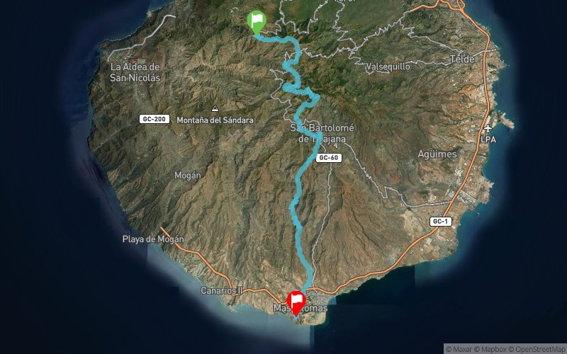
 Artenara (ES)
 Las Meloneras (ES)
A NEW DISTANCE FOR THE ADVANCED
The Advanced race will experience one of the most attractive modifications for 2018. “This ultradistance race will change to facilitate the leap from the Marathon to a higher distance”, states Fernando González, sports and communication manager of Arista Eventos, company in charge of the race.
The Advanced course will begin in Artenara and will have a 64 km track with 3,200 metres of positive gain. “Having the chance to host one of Transgrancanaria’s races start offers the opportunity to set Artenara in the world’s trail running map, and reinforces our town as one of the most important touristic destinations in Gran Canaria for this sport”, explained Roberto García, mayor of Artenara.
From Artenara, the runners will go through the Riscos de Chapín and Los Moriscos to Tejeda, where they will connect with the traditional course of the race.
Points of Interest table
| Accum. | Intermediary | |||||||
|---|---|---|---|---|---|---|---|---|
| POI | Description | Alt. | Dist. | D+ | D- | Dist. | D+ | D- |
 Competition organized on 02/24/2018
Trace n°68035
Ascent threshold : 3 m Distance threshold : 30 m Smoothing : No Origin of altitudes : MNT Aster GDEM
Ascent threshold : 3 m Distance threshold : 30 m Smoothing : No Origin of altitudes : MNT Aster GDEM
Crossing
Dominant terrain : Footpath
Max alti. : 1865 m
Avg alti. : 996 m
Min alti. : 12 m
Longest ascent : 820 m
Longest descent : 1050 m
Dominant terrain : Footpath
Max alti. : 1865 m
Avg alti. : 996 m
Min alti. : 12 m
Longest ascent : 820 m
Longest descent : 1050 m
Elevation profile
More tools
Create a new roadbook page
Map and track on your website
Warning ! When you insert a Trace de Trail map on your website, you agree not to hide any element of the module (links to Trail Trail or Trail Connect banner)
Add a realisation
Validate
Add a realisation to share your chrono and describe the conditions that you encountered during you trail running !
Add a comment
Validate
Sabi_gti
14/09/18, 13:21:47
Track obtained from the official page Trace de TRail: https://tracedetrail.com/fr/trace/trace/39729 le calcul du profil de votre trace pour le passer du MNT Google. au MNT ASTERGDEM. Avec le MNT Google, le profil est plus lisse, Et il s'éloigne de la réalité de la course.
14/09/18, 13:21:47
Track obtained from the official page Trace de TRail: https://tracedetrail.com/fr/trace/trace/39729 le calcul du profil de votre trace pour le passer du MNT Google. au MNT ASTERGDEM. Avec le MNT Google, le profil est plus lisse, Et il s'éloigne de la réalité de la course.
Show the infos
Add a track


