Show the map
Certified Track - ITRA
October Trail 2018 - M
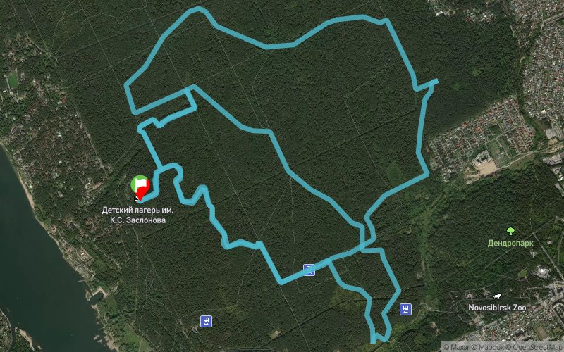


20.3 km
490 m
430 m
 ???????????? (RU)
 3
3 330
330 Points of Interest table
| Accum. | Intermediary | |||||||
|---|---|---|---|---|---|---|---|---|
| POI | Description | Alt. | Dist. | D+ | D- | Dist. | D+ | D- |
 Competition organized on 10/14/2018
Trace n°67811
Ascent threshold : 0 m Distance threshold : 0 m Smoothing : No Origin of altitudes : GPS
Ascent threshold : 0 m Distance threshold : 0 m Smoothing : No Origin of altitudes : GPS
Loop
Dominant terrain : Path
Max alti. : 157 m
Avg alti. : 129 m
Min alti. : 58 m
Longest ascent : 480 m
Longest descent : 40 m
Dominant terrain : Path
Max alti. : 157 m
Avg alti. : 129 m
Min alti. : 58 m
Longest ascent : 480 m
Longest descent : 40 m
Elevation profile
More tools
Create a new roadbook page
Map and track on your website
Warning ! When you insert a Trace de Trail map on your website, you agree not to hide any element of the module (links to Trail Trail or Trail Connect banner)
Add a realisation
Validate
Add a realisation to share your chrono and describe the conditions that you encountered during you trail running !
Add a comment
Validate
Admin - Trace de Trail
11/09/18, 21:02:43
Bonjour, Merci de classer votre trace en compétition et de la renommer avant de la placer en public.
11/09/18, 21:02:43
Bonjour, Merci de classer votre trace en compétition et de la renommer avant de la placer en public.
Show the infos
Add a track


