Show the map
Watterdal - Mont du Lusquet
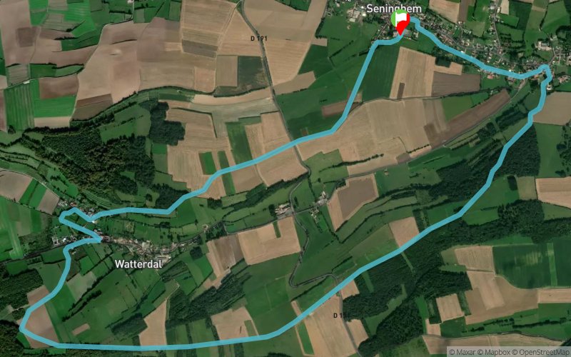


9.8 km
163 m
165 m
 Seninghem (62)
 Points of Interest table
| Accum. | Intermediary | |||||||
|---|---|---|---|---|---|---|---|---|
| POI | Description | Alt. | Dist. | D+ | D- | Dist. | D+ | D- |
Trace n°5623
Ascent threshold : 3 m Distance threshold : 30 m Smoothing : Yes Origin of altitudes : MNT Aster GDEM
Ascent threshold : 3 m Distance threshold : 30 m Smoothing : Yes Origin of altitudes : MNT Aster GDEM
Loop
Dominant terrain : Footpath
Max alti. : 178 m
Avg alti. : 128 m
Min alti. : 62 m
Longest ascent : 68 m
Longest descent : 104 m
Route completed by the author : nc
Dominant terrain : Footpath
Max alti. : 178 m
Avg alti. : 128 m
Min alti. : 62 m
Longest ascent : 68 m
Longest descent : 104 m
Route completed by the author : nc
Elevation profile
More tools
Create a new roadbook page
Map and track on your website
Warning ! When you insert a Trace de Trail map on your website, you agree not to hide any element of the module (links to Trail Trail or Trail Connect banner)
Add a realisation
Validate
Add a comment
Validate
boule
19/07/15, 13:28:26
le 19/07/15 j ai essayer de faire le parcours il manque des fléchage. Ns ns sommes perdu résultat 1h40 avec 16 km parcouru.
19/07/15, 13:28:26
le 19/07/15 j ai essayer de faire le parcours il manque des fléchage. Ns ns sommes perdu résultat 1h40 avec 16 km parcouru.
Show the infos
Add a track


