Show the map
Laneuville - Sémilly sous Laon - La Cuve St-Vincent - La Valise - Brunehaut
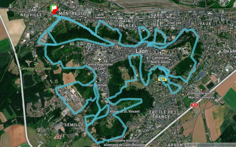


23 km
1040 m
1030 m
 Laon (02)
 Points of Interest table
| Accum. | Intermediary | |||||||
|---|---|---|---|---|---|---|---|---|
| POI | Description | Alt. | Dist. | D+ | D- | Dist. | D+ | D- |
Trace n°53044
Ascent threshold : 3 m Distance threshold : 30 m Smoothing : Yes Origin of altitudes : MNT Aster GDEM
Ascent threshold : 3 m Distance threshold : 30 m Smoothing : Yes Origin of altitudes : MNT Aster GDEM
Loop
Dominant terrain : Path
Max alti. : 183 m
Avg alti. : 123 m
Min alti. : 67 m
Longest ascent : 100 m
Longest descent : 100 m
Route completed by the author : nc
Dominant terrain : Path
Max alti. : 183 m
Avg alti. : 123 m
Min alti. : 67 m
Longest ascent : 100 m
Longest descent : 100 m
Route completed by the author : nc
Elevation profile
More tools
Create a new roadbook page
Map and track on your website
Warning ! When you insert a Trace de Trail map on your website, you agree not to hide any element of the module (links to Trail Trail or Trail Connect banner)
Add a realisation
Validate
Add a realisation to share your chrono and describe the conditions that you encountered during you trail running !
Add a comment
Validate
jmvivot29
26/06/18, 10:47:40
Bonjour Si ça vous dit, je ferais bien le parcours avec vous? Sportivement. Jean matthieu vivot
26/06/18, 10:47:40
Bonjour Si ça vous dit, je ferais bien le parcours avec vous? Sportivement. Jean matthieu vivot
Show the infos
Add a track


