Show the map
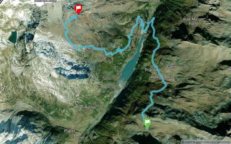
Ref. de l'Epée - Ref. Degli Angeli


13.2 km
1300 m
750 m


Points of Interest table
Accum. | Intermediary | |||||||
---|---|---|---|---|---|---|---|---|
POI | Description | Alt. | Dist. | D+ | D- | Dist. | D+ | D- |
Trace n°52345
Ascent threshold : 3 m Distance threshold : 30 m Smoothing : Yes Origin of altitudes : MNT Aster GDEM
Crossing
Dominant terrain : Footpath
Max alti. : 2938 m
Avg alti. : 2148 m
Min alti. : 1697 m
Longest ascent : 1050 m
Longest descent : 720 m
Route completed by the author : nc
Dominant terrain : Footpath
Max alti. : 2938 m
Avg alti. : 2148 m
Min alti. : 1697 m
Longest ascent : 1050 m
Longest descent : 720 m
Route completed by the author : nc
Elevation profile

Their last tracks
More tools
Create a new roadbook page
Carte à la Carte IGN
Map and track on your website
Warning ! When you insert a Trace de Trail map on your website, you agree not to hide any element of the module (links to Trail Trail or Trail Connect banner)
Add a realisation
Validate
Add a realisation to share your chrono and describe the conditions that you encountered during you trail running !
Add a comment
Validate
Nearby tracks
11.9 km Refuge Benevola - Pointe de la Traversière - Lac Noir - Refuge Bezzi
27.3 km
2210 m
2210 m
Val-d’Isère (73)
11.9 km Rif. Gran Frederico - Lago di Goletta - Col Bassac Deré - Rif. Mario Bezzi
10.4 km
850 m
860 m
Val-d’Isère (73)
14.4 km Ref. de Ruito - Col du Petit St-Bernard - Col de la Seigne - Le Nid d'Aigle
89.7 km
6050 m
7050 m
Sainte-Foy-Tarentaise (73)
Show the infos
Add a track