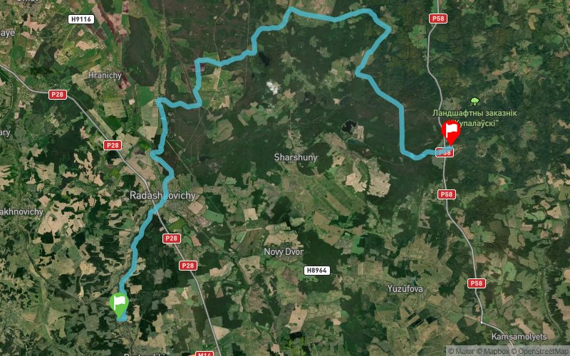
Show the map
Evaluated Track - ITRA
Zima Minus 100 2018 - Trail 50


 ???????? (BY)
 ?????? (BY)

Linear trail and cycling race. Unmarked route avoiding asphalt roads.
50 and 100km running
100km cycling.
Cut-off time 24h. It is a hard challenge that requires experience, motivation and good physical fitness.
-----------—
What to expect: the true winter adventure, frosty air, and tranquility of the "white silence" in the woods.
The route is unmarked. There are 10 control points and recommended track. There are also road sections forbidden to use (grade M highways and grade P regional roads).
Navigation is easy, but basic experience of navigation using a map or GPS is encouraged.
Start 9:30 - village Vyazynka, Minsk region (J. Kupala museum)
Intermediate cut-off time 10h (19:30) - approximately halfway, village Zhukovka, Minsk region: refreshment point with fireplace, hot food, opportunity to abandon the race (there are buses to Minsk running hourly from Zhukovka)
Finish before 09:30 on 28.01.18: fireplace and hot tea in Valeryanovo park, Minsk (closest tube station Uru??a)
The trail will be different from the last year. The less snow there will be, the more abandoned forest roads will be used.
Passage of the check points will be reported by participants either by taking "selfie" at the control points or the track registered and published via https://www.strava.com/
Participant's bag includes: electronic track, map of the route, photographer's work, tea, snacks and hot food during the race, transfer of bags to finish line, finisher's medal.
Points of Interest table
| Accum. | Intermediary | |||||||
|---|---|---|---|---|---|---|---|---|
| POI | Description | Alt. | Dist. | D+ | D- | Dist. | D+ | D- |
 Competition organized on 01/27/2018
Trace n°50911
Ascent threshold : 3 m Distance threshold : 30 m Smoothing : Yes Origin of altitudes : MNT Google
Ascent threshold : 3 m Distance threshold : 30 m Smoothing : Yes Origin of altitudes : MNT Google
Crossing
Dominant terrain : Footpath
Max alti. : 267 m
Avg alti. : 217 m
Min alti. : 178 m
Longest ascent : 80 m
Longest descent : 90 m
Dominant terrain : Footpath
Max alti. : 267 m
Avg alti. : 217 m
Min alti. : 178 m
Longest ascent : 80 m
Longest descent : 90 m
Elevation profile
More tools
Create a new roadbook page
Map and track on your website
Warning ! When you insert a Trace de Trail map on your website, you agree not to hide any element of the module (links to Trail Trail or Trail Connect banner)
Add a realisation
Validate
Add a realisation to share your chrono and describe the conditions that you encountered during you trail running !
Add a comment
Validate
Show the infos
Add a track


