Show the map
Certified Track - ITRA
Manitou's Revenge 2018 - Ultramarathon and Relay
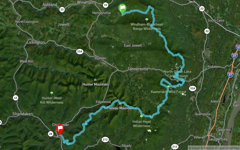


 Maplecrest (US)
 Phoenicia (US)


This is a grueling, gnarly, nasty course with approximately 15,000 ft. of climbing, much of it rocky and precipitous. To be sure, there are some runnable sections, but you will more often find yourself hiking uphill or down, sometimes hand over hand. Expect this course to take you much longer than your average 50 miler. That’s why we are allowing 24 hrs. to complete this monster. Because of its remote and difficult nature, there will of necessity be a limited number of aid stations, only 9, and runners should be prepared to spend up to 3 or 4 hrs between aid stations. You will have to be reasonably self-sufficient. To make matters worse, the course gets progressively more difficult as you go along! And to top it all off, the average runner will have to tackle this hardest terrain in the dark.
Points of Interest table
| Accum. | Intermediary | |||||||
|---|---|---|---|---|---|---|---|---|
| POI | Description | Alt. | Dist. | D+ | D- | Dist. | D+ | D- |
 Competition organized on 06/23/2018
Trace n°50495
Ascent threshold : 3 m Distance threshold : 0 m Smoothing : No Origin of altitudes : GPS
Ascent threshold : 3 m Distance threshold : 0 m Smoothing : No Origin of altitudes : GPS
Crossing
Dominant terrain : Footpath
Max alti. : 1192 m
Avg alti. : 791 m
Min alti. : 186 m
Longest ascent : 560 m
Longest descent : 590 m
Dominant terrain : Footpath
Max alti. : 1192 m
Avg alti. : 791 m
Min alti. : 186 m
Longest ascent : 560 m
Longest descent : 590 m
Elevation profile
More tools
Create a new roadbook page
Map and track on your website
Warning ! When you insert a Trace de Trail map on your website, you agree not to hide any element of the module (links to Trail Trail or Trail Connect banner)
Add a realisation
Validate
Add a realisation to share your chrono and describe the conditions that you encountered during you trail running !
Add a comment
Validate
Show the infos
Add a track


