Show the map
Trail des Goyaves 2018


 Inconnu (MU)
 Inconnu (MU)
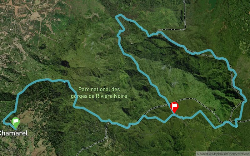
Start in Chamarel village, 600m of road before climbing to the highest point of Mauritius, Piton de la Riviere Noire on technical singletrack, then turn along the crest of the ridge to Plaine Champagne 3km distance, to the viewpoint on more singeltracks, then a track to the Parakeet antenna on 1km of road, turning onto more narrow singletrack crossing rivers and small descents and climbs, into a pine forest with track, until Petrin where there is a vechicle track leading ot the top of the Black River Gorges, going down into the valley on slippery mud path and crossing the main river at 100m altitude, then a climb back up the steepest path in Mauritius to the Parakeet Antenna.
Points of Interest table
| Accum. | Intermediary | |||||||
|---|---|---|---|---|---|---|---|---|
| POI | Description | Alt. | Dist. | D+ | D- | Dist. | D+ | D- |
 Competition organized on 04/07/2018
Trace n°50272
Ascent threshold : 3 m Distance threshold : 0 m Smoothing : No Origin of altitudes : GPS
Ascent threshold : 3 m Distance threshold : 0 m Smoothing : No Origin of altitudes : GPS
Crossing
Dominant terrain : Footpath
Max alti. : 763 m
Avg alti. : 522 m
Min alti. : 109 m
Longest ascent : 620 m
Longest descent : 540 m
Dominant terrain : Footpath
Max alti. : 763 m
Avg alti. : 522 m
Min alti. : 109 m
Longest ascent : 620 m
Longest descent : 540 m
Elevation profile
More tools
Create a new roadbook page
Map and track on your website
Warning ! When you insert a Trace de Trail map on your website, you agree not to hide any element of the module (links to Trail Trail or Trail Connect banner)
Add a realisation
Validate
Add a realisation to share your chrono and describe the conditions that you encountered during you trail running !
Add a comment
Validate
Show the infos
Add a track


