Show the map
Trail du St-Joseph 2022 - 7 km
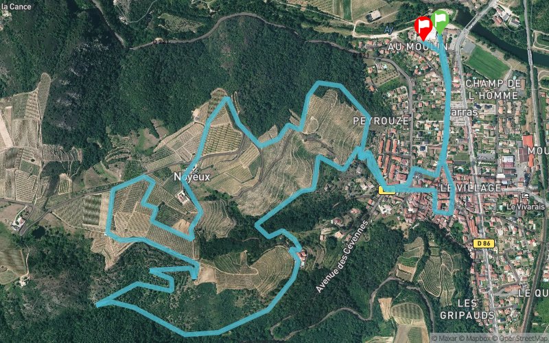


7.1 km
270 m
280 m
 Sarras (07)
 Sarras (07)
 Points of Interest table
| Accum. | Intermediary | |||||||
|---|---|---|---|---|---|---|---|---|
| POI | Description | Alt. | Dist. | D+ | D- | Dist. | D+ | D- |
 Competition organized on 05/27/2018
Trace n°48612
Ascent threshold : 0 m Distance threshold : 30 m Smoothing : Yes Origin of altitudes : MNT Aster GDEM
Ascent threshold : 0 m Distance threshold : 30 m Smoothing : Yes Origin of altitudes : MNT Aster GDEM
Loop
Dominant terrain : Footpath
Max alti. : 315 m
Avg alti. : 221 m
Min alti. : 128 m
Longest ascent : 260 m
Longest descent : 190 m
Dominant terrain : Footpath
Max alti. : 315 m
Avg alti. : 221 m
Min alti. : 128 m
Longest ascent : 260 m
Longest descent : 190 m
Elevation profile
More tools
Create a new roadbook page
Map and track on your website
Warning ! When you insert a Trace de Trail map on your website, you agree not to hide any element of the module (links to Trail Trail or Trail Connect banner)
Add a realisation
Validate
Add a realisation to share your chrono and describe the conditions that you encountered during you trail running !
Add a comment
Validate
Admin - Trace de Trail
08/03/19, 22:24:20
Bonjour, Merci de créer une nouvelle trace pour l'édition 2019 de ce trail. C'est la date de compétition qui est utilisée pour le calendrier des courses...
08/03/19, 22:24:20
Bonjour, Merci de créer une nouvelle trace pour l'édition 2019 de ce trail. C'est la date de compétition qui est utilisée pour le calendrier des courses...
Show the infos
Add a track


