Show the map
Marche au clair de lune 2014 - parcours théorique
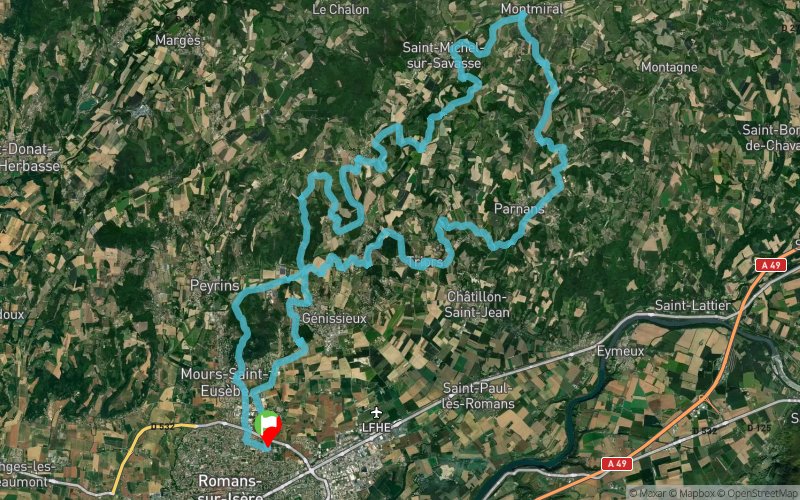


 Romans-sur-Isère (26)
 Points of Interest table
| Accum. | Intermediary | |||||||
|---|---|---|---|---|---|---|---|---|
| POI | Description | Alt. | Dist. | D+ | D- | Dist. | D+ | D- |
Trace n°4617
Ascent threshold : 0 m Distance threshold : 35 m Smoothing : Yes Origin of altitudes : MNT Aster GDEM
Ascent threshold : 0 m Distance threshold : 35 m Smoothing : Yes Origin of altitudes : MNT Aster GDEM
Loop
Dominant terrain : Path
Max alti. : 442 m
Avg alti. : 271 m
Min alti. : 155 m
Longest ascent : 186 m
Longest descent : 149 m
Route completed by the author : nc
Dominant terrain : Path
Max alti. : 442 m
Avg alti. : 271 m
Min alti. : 155 m
Longest ascent : 186 m
Longest descent : 149 m
Route completed by the author : nc
Elevation profile
More tools
Create a new roadbook page
Map and track on your website
Warning ! When you insert a Trace de Trail map on your website, you agree not to hide any element of the module (links to Trail Trail or Trail Connect banner)
Add a realisation
Validate
Add a realisation to share your chrono and describe the conditions that you encountered during you trail running !
Add a comment
Validate
26manu26
07/10/14, 21:56:41
07/10/14, 21:56:41
Traces suivant informations ici:
http://www.lamarcheauclairdelune.fr/
27ème édition – 18 et 19 octobre 2014
Show the infos
Add a track


