Show the map
Ronde des Dolmens 2014
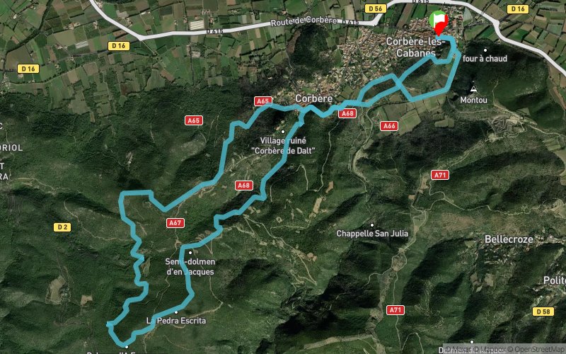


12.5 km
521 m
522 m
 Corbère-les-Cabanes (66)
 Points of Interest table
| Accum. | Intermediary | |||||||
|---|---|---|---|---|---|---|---|---|
| POI | Description | Alt. | Dist. | D+ | D- | Dist. | D+ | D- |
 Competition organized on 07/19/2014
Trace n°4250
Ascent threshold : 0 m Distance threshold : 35 m Smoothing : Yes Origin of altitudes : MNT Aster GDEM
Ascent threshold : 0 m Distance threshold : 35 m Smoothing : Yes Origin of altitudes : MNT Aster GDEM
Loop
Dominant terrain : Footpath
Max alti. : 507 m
Avg alti. : 297 m
Min alti. : 140 m
Longest ascent : 310 m
Longest descent : 384 m
Dominant terrain : Footpath
Max alti. : 507 m
Avg alti. : 297 m
Min alti. : 140 m
Longest ascent : 310 m
Longest descent : 384 m
Elevation profile
More tools
Create a new roadbook page
Map and track on your website
Warning ! When you insert a Trace de Trail map on your website, you agree not to hide any element of the module (links to Trail Trail or Trail Connect banner)
Add a realisation
Validate
Add a realisation to share your chrono and describe the conditions that you encountered during you trail running !
Add a comment
Validate
FloC
18/05/17, 11:42:46
Avec quelques détours, j'étais plutôt autour de 15km sur cette trace. Sentier plutôt technique, à faire lucide
18/05/17, 11:42:46
Avec quelques détours, j'étais plutôt autour de 15km sur cette trace. Sentier plutôt technique, à faire lucide
Show the infos
Add a track


