Show the map
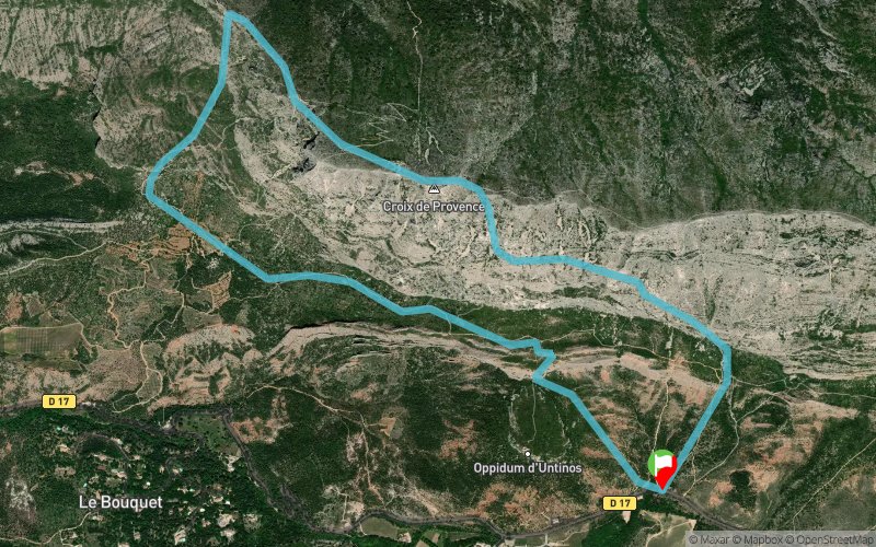
Les Deux Aiguilles - Pas de l'Escalette - Refuge Cézanne


6.3 km
620 m
620 m
 Saint-Antonin-sur-Bayon (13)
du parkink monter en suivant le sentier noir, au trou du garagai, poursuivre sur la gauche vers la croix puis le prieuré, descendre par le sentier bleu jusqu'à un gros kern, prendre sur la gauche en suivant le sentier rouge puis au refuge Cézanne rentrer par le sentier marron
Points of Interest table
| Accum. | Intermediary | |||||||
|---|---|---|---|---|---|---|---|---|
| POI | Description | Alt. | Dist. | D+ | D- | Dist. | D+ | D- |
Trace n°36354
Ascent threshold : 3 m Distance threshold : 30 m Smoothing : Yes Origin of altitudes : MNT Aster GDEM
Ascent threshold : 3 m Distance threshold : 30 m Smoothing : Yes Origin of altitudes : MNT Aster GDEM
Loop
Dominant terrain : Footpath
Max alti. : 927 m
Avg alti. : 610 m
Min alti. : 442 m
Longest ascent : 490 m
Longest descent : 480 m
Route completed by the author : nc
Dominant terrain : Footpath
Max alti. : 927 m
Avg alti. : 610 m
Min alti. : 442 m
Longest ascent : 490 m
Longest descent : 480 m
Route completed by the author : nc
Elevation profile
More tools
Create a new roadbook page
Map and track on your website
Warning ! When you insert a Trace de Trail map on your website, you agree not to hide any element of the module (links to Trail Trail or Trail Connect banner)
Add a realisation
Validate
Add a realisation to share your chrono and describe the conditions that you encountered during you trail running !
Add a comment
Validate
Show the infos
Add a track


