Show the map
Aktivitus Trailrace 2017 - Ultra Trail
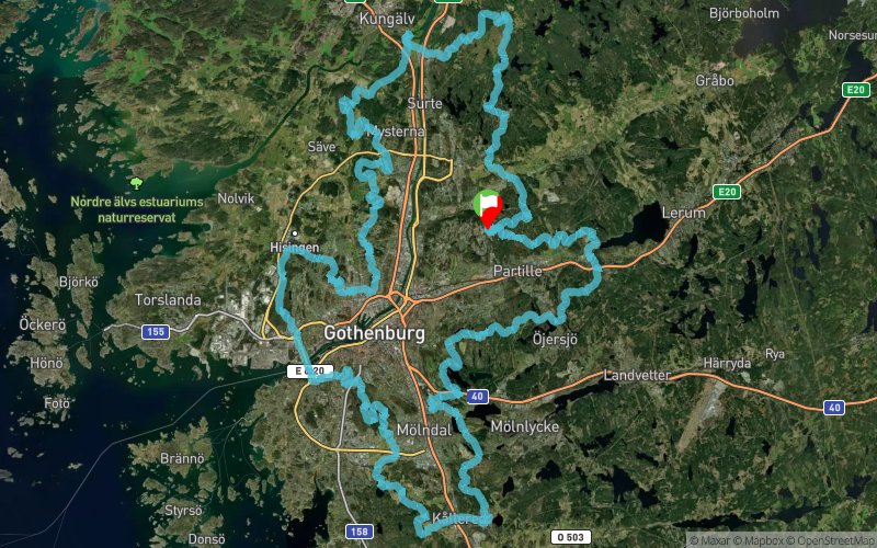


161.9 km
5510 m
5510 m
 Angered (SE)
 ()
() Points of Interest table
| Accum. | Intermediary | |||||||
|---|---|---|---|---|---|---|---|---|
| POI | Description | Alt. | Dist. | D+ | D- | Dist. | D+ | D- |
 Competition organized on 07/01/2017
Trace n°35781
Ascent threshold : 3 m Distance threshold : 30 m Smoothing : Yes Origin of altitudes : MNT Aster GDEM
Ascent threshold : 3 m Distance threshold : 30 m Smoothing : Yes Origin of altitudes : MNT Aster GDEM
Crossing
Dominant terrain : Footpath
Max alti. : 176 m
Avg alti. : 68 m
Min alti. : 3 m
Longest ascent : 130 m
Longest descent : 120 m
Dominant terrain : Footpath
Max alti. : 176 m
Avg alti. : 68 m
Min alti. : 3 m
Longest ascent : 130 m
Longest descent : 120 m
More tools
Create a new roadbook page
Map and track on your website
Warning ! When you insert a Trace de Trail map on your website, you agree not to hide any element of the module (links to Trail Trail or Trail Connect banner)
Add a realisation
Validate
Add a realisation to share your chrono and describe the conditions that you encountered during you trail running !
Add a comment
Validate
Aktivitus Sports Club
12/04/17, 17:28:16
Gothenburg’s first Ultra Trail of 100 miles, or 161 km. It’s a hard race with a narrow medal time in just under 18 hours, sunrise to sunset, and a maximum time of 24 hours. The race consists of a lap around Gothenburg on singeltrail, tracks and roads with a preliminary ascent of 3800 meters.
Show the infos
Add a track


