Show the map
Evaluated Track - ITRA
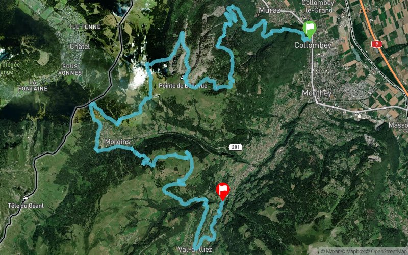
Trail de Bellevue 2017 - 40 km


 Collombey (CH)
 Troistorrents (CH)


40K For runners, relays or in patrol of 2. 2461m D +, 2105m D- For the relay race, the witness goes to Pas de Morgins. Relay 1: 23,2K (1968m D + and 1003m D-) Relay 2: 16,8K (493m D + and 1102m D) Description of the route: The departure is given at the intersection of the Rue de la Charmette and Carriers. One directly attacks the climb on the old dump. The riders then rejoin the chemin des Carrières and follow it towards Muraz. After the climb towards the Pont des Fours, a short descent before attacking the climb to the Croix du Rovra, Chatillon, Essert (small check in passing). Race on 200m on the road of Draversaz and we continue towards Grande Ravine, Chemenau where it is possible to quench thirst. A small dish to recover before returning to the Cavoues, Grand Crau, Queues. The Pointe de Bellevue is just to the right.
We take advantage of the view of the Dents-du-Midi at Bellevue, before descending into the Combe de Dreveneuse and crossing a gentle climb to reach Pré Fleuri, Chalet-Neuf. The last climb is well rewarded with the refueling at Portes-du-Culet. The descent can be done serenely until the Pas-de-Morgins, where the relayers wait to leave in their turn. The runners bypass the lake of Morgins, no time to feed the ducks ... We join the chairlift of the Foilleuse by the forest ... No, no one does not cheat, it is by the paths of the Abérieu that the " We join Savolaire! A small break is well deserved, we take the pose, we enjoy the view and we leave for the descent!
The Jorat, Séchaux, Crie d'en Haut, Cree d'En Bas, a little detour by Val d'Illiez by the forest ... Passage near the Baths, but it will be for later ... We walk along the Vièze through the forest, Up to the Fayot stadium! This year, you are given the turn of honor ... You can quench your thirst and take a well-deserved shower! Congratulations In case of bad weather, the descent into the Combe de Dreveneuse will not take place.
Points of Interest table
| Accum. | Intermediary | |||||||
|---|---|---|---|---|---|---|---|---|
| POI | Description | Alt. | Dist. | D+ | D- | Dist. | D+ | D- |
 Competition organized on 09/02/2017
Trace n°33761
Ascent threshold : 3 m Distance threshold : 30 m Smoothing : Yes Origin of altitudes : MNT Aster GDEM
Ascent threshold : 3 m Distance threshold : 30 m Smoothing : Yes Origin of altitudes : MNT Aster GDEM
Crossing
Dominant terrain : Footpath
Max alti. : 2041 m
Avg alti. : 1279 m
Min alti. : 396 m
Longest ascent : 1390 m
Longest descent : 1020 m
Dominant terrain : Footpath
Max alti. : 2041 m
Avg alti. : 1279 m
Min alti. : 396 m
Longest ascent : 1390 m
Longest descent : 1020 m
Elevation profile
More tools
Create a new roadbook page
Map and track on your website
Warning ! When you insert a Trace de Trail map on your website, you agree not to hide any element of the module (links to Trail Trail or Trail Connect banner)
Add a realisation
Validate
Add a realisation to share your chrono and describe the conditions that you encountered during you trail running !
Add a comment
Validate
Show the infos
Add a track


