Show the map
Ultra Trail Adventure Run 2017
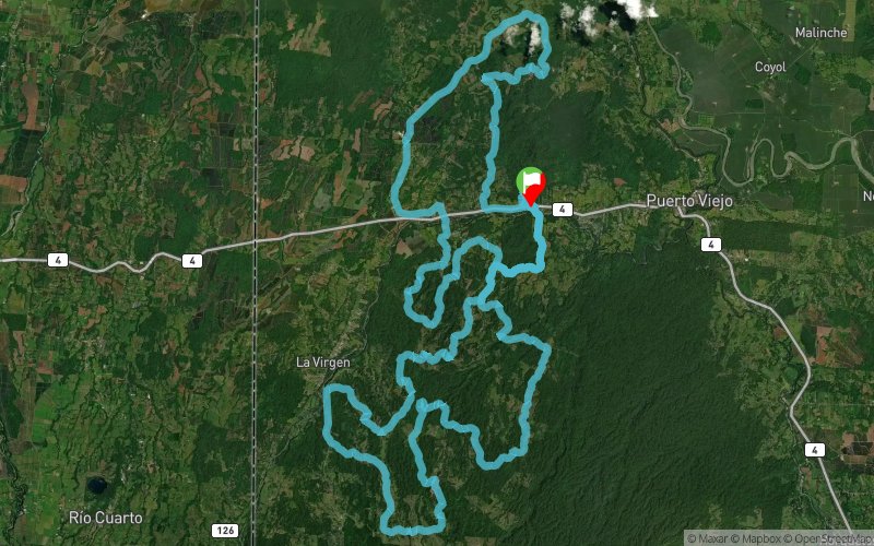


107.4 km
2010 m
2010 m
 La Virgen (CR)
 Points of Interest table
| Accum. | Intermediary | |||||||
|---|---|---|---|---|---|---|---|---|
| POI | Description | Alt. | Dist. | D+ | D- | Dist. | D+ | D- |
 Competition organized on 10/21/2017
Trace n°32685
Ascent threshold : 3 m Distance threshold : 30 m Smoothing : Yes Origin of altitudes : MNT Aster GDEM
Ascent threshold : 3 m Distance threshold : 30 m Smoothing : Yes Origin of altitudes : MNT Aster GDEM
Loop
Dominant terrain : Path
Max alti. : 426 m
Avg alti. : 158 m
Min alti. : 28 m
Longest ascent : 240 m
Longest descent : 170 m
Dominant terrain : Path
Max alti. : 426 m
Avg alti. : 158 m
Min alti. : 28 m
Longest ascent : 240 m
Longest descent : 170 m
Elevation profile
More tools
Create a new roadbook page
Map and track on your website
Warning ! When you insert a Trace de Trail map on your website, you agree not to hide any element of the module (links to Trail Trail or Trail Connect banner)
Add a realisation
Validate
Add a realisation to share your chrono and describe the conditions that you encountered during you trail running !
Add a comment
Validate
SentirCostaRica
05/02/17, 21:39:38
Course might not have a lot of elevation gain for a 110km, but other things come to play. Very hot and humid weather. Temperatures can reach 100-110 F with levels of humidity reaching close to 100%. Not a race for the weak of mind!!!! The course will test you like no other before, just the way you like it!
Show the infos
Warning ! This track is only accessible on the day of the competition.
Add a track


