Show the map
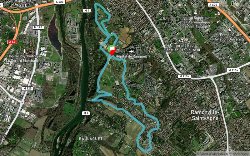
Côtes de Pech David - Le Salas - Gleyze Vieille - Pouvourville


11.1 km
240 m
250 m

Points of Interest table
Accum. | Intermediary | |||||||
---|---|---|---|---|---|---|---|---|
POI | Description | Alt. | Dist. | D+ | D- | Dist. | D+ | D- |
Trace n°31538
Ascent threshold : 3 m Distance threshold : 30 m Smoothing : Yes Origin of altitudes : MNT Aster GDEM
Loop
Dominant terrain : Footpath
Max alti. : 246 m
Avg alti. : 208 m
Min alti. : 155 m
Longest ascent : 50 m
Longest descent : 80 m
Route completed by the author : nc
Dominant terrain : Footpath
Max alti. : 246 m
Avg alti. : 208 m
Min alti. : 155 m
Longest ascent : 50 m
Longest descent : 80 m
Route completed by the author : nc
Elevation profile

Their last tracks
More tools
Create a new roadbook page
Carte à la Carte IGN
Map and track on your website
Warning ! When you insert a Trace de Trail map on your website, you agree not to hide any element of the module (links to Trail Trail or Trail Connect banner)
Add a realisation
Validate
Add a realisation to share your chrono and describe the conditions that you encountered during you trail running !
Add a comment
Validate
Nearby tracks
0.2 km La Cornasse - Les Frisats - Le Salas - Pouvourville
10.2 km
250 m
250 m
Ramonville-Saint-Agne (31)
0.2 km La Plaine - Le Salas - Pechbusque - Pouvourville
15 km
490 m
480 m
Ramonville-Saint-Agne (31)
1.0 km Pouvourville - Le Salas - Pechbusque - St-Sernin
11.3 km
360 m
360 m
Ramonville-Saint-Agne (31)
Show the infos
Add a track