Show the map
Evaluated Track - ITRA
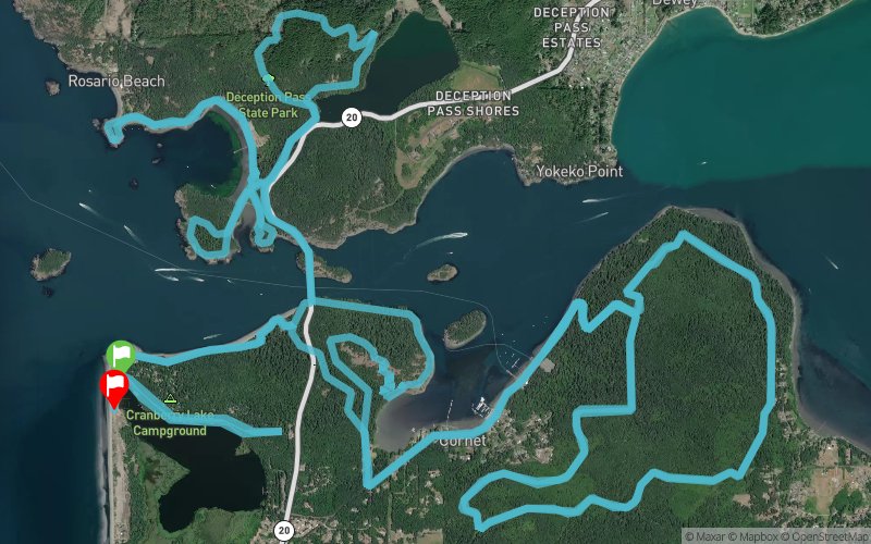
Deception Pass 2016 - 50 km


 Oak Harbor (US)
 Oak Harbor (US)


Taking place at Deception Pass State Park which is named for the narrow and dramatic channel of water that separates Whidbey and Fidalgo Islands in the northern Puget Sound. The area is famous for it's rugged coastline, steep cliffs, dense forests and great views. The race covers just about every inch of the park, running at times right at sea level and other times high above on bluffs and hills and twice crosses the pass itself via the historic Deception Pass Bridge which sits about 180 feet above the water. There are no mountains or long climbs like many of our other Rainshadow Running Races but make no mistake Deception Pass 50k is still a tough race with it's technical footing, narrow, twisty trails and at times steep grades. It maybe be one of our faster courses but it's still a good challenge!
Points of Interest table
| Accum. | Intermediary | |||||||
|---|---|---|---|---|---|---|---|---|
| POI | Description | Alt. | Dist. | D+ | D- | Dist. | D+ | D- |
 Competition organized on 12/10/2016
Trace n°28037
Ascent threshold : 3 m Distance threshold : 30 m Smoothing : Yes Origin of altitudes : MNT Aster GDEM
Ascent threshold : 3 m Distance threshold : 30 m Smoothing : Yes Origin of altitudes : MNT Aster GDEM
Loop
Dominant terrain : Footpath
Max alti. : 149 m
Avg alti. : 44 m
Min alti. : 0 m
Longest ascent : 170 m
Longest descent : 140 m
Dominant terrain : Footpath
Max alti. : 149 m
Avg alti. : 44 m
Min alti. : 0 m
Longest ascent : 170 m
Longest descent : 140 m
Elevation profile
More tools
Create a new roadbook page
Map and track on your website
Warning ! When you insert a Trace de Trail map on your website, you agree not to hide any element of the module (links to Trail Trail or Trail Connect banner)
Add a realisation
Validate
Add a realisation to share your chrono and describe the conditions that you encountered during you trail running !
Add a comment
Validate
Show the infos
Add a track


