Show the map
Garmin Mountain Marathon 2017 - Garmin 100


 Inconnu (HK)
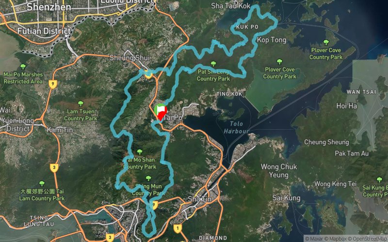
The Garmin 100 is one of the most demanding endurance trail race in Hong Kong. The 100km course starts and finishes at Tai Po in a clockwise direction. Starting and finishing at Tai Po in the New Territories, runners face over 5,800m of cumulative elevation gain on the 100km course, including Hong Kong’s highest peak Tai Mo Shan. Runners will enjoy wonderful views over Hong Kong as they race along ridges, remote villages, ancient forests, reservoir and nature trails. Highlights of the course include running over the scenic Plover Cove Country Trail, passing through the historic Chinese villages Kuk Po and Lai Chi Wo, and dramatic views along Hong Kong’s longest ridge, Ping Fung Shan and Pat Sin Leng to the finish.
Points of Interest table
| Accum. | Intermediary | |||||||
|---|---|---|---|---|---|---|---|---|
| POI | Description | Alt. | Dist. | D+ | D- | Dist. | D+ | D- |
 Competition organized on 02/18/2017
Trace n°27692
Ascent threshold : 10 m Distance threshold : 0 m Smoothing : No Origin of altitudes : GPS
Ascent threshold : 10 m Distance threshold : 0 m Smoothing : No Origin of altitudes : GPS
Loop
Dominant terrain : Path
Max alti. : 919 m
Avg alti. : 276 m
Min alti. : 0 m
Longest ascent : 610 m
Longest descent : 820 m
Dominant terrain : Path
Max alti. : 919 m
Avg alti. : 276 m
Min alti. : 0 m
Longest ascent : 610 m
Longest descent : 820 m
Elevation profile
More tools
Create a new roadbook page
Map and track on your website
Warning ! When you insert a Trace de Trail map on your website, you agree not to hide any element of the module (links to Trail Trail or Trail Connect banner)
Add a realisation
Validate
Add a realisation to share your chrono and describe the conditions that you encountered during you trail running !
Add a comment
Validate
Show the infos
Add a track


