Show the map
Le Mont - Chalet des Pyramides - La Jonction


 Chamonix-Mont-Blanc (74)
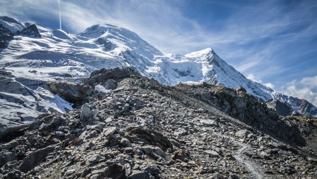
La Jonction (The Junction) is one of the classics of the Mont Blanc Massif and the Chamonix Valley. Joining the Bossons and Taconnaz Glaciers, La Jonction offers a staggering view of the Aiguille du Midi, the Dôme du Gôuter as well as the Aiguilles Rouges. La Jonction constitutes an exceptional site as it allows treading on two glaciers and observe their seracs and crevasses in an enchanting environment. The high elevation gain represents the sole difficulty of the hike. Furthermore, hikers have to be very careful when the soil is wet as the rocks in the final part of the ascent can be very slippery.
Points of Interest table
| Accum. | Intermediary | |||||||
|---|---|---|---|---|---|---|---|---|
| POI | Description | Alt. | Dist. | D+ | D- | Dist. | D+ | D- |
Trace n°27115
Ascent threshold : 10 m Distance threshold : 30 m Smoothing : Yes Origin of altitudes : MNT Aster GDEM
Ascent threshold : 10 m Distance threshold : 30 m Smoothing : Yes Origin of altitudes : MNT Aster GDEM
Loop
Dominant terrain : Path
Max alti. : 2563 m
Avg alti. : 1806 m
Min alti. : 1134 m
Longest ascent : 1470 m
Longest descent : 1440 m
Route completed by the author : nc
Dominant terrain : Path
Max alti. : 2563 m
Avg alti. : 1806 m
Min alti. : 1134 m
Longest ascent : 1470 m
Longest descent : 1440 m
Route completed by the author : nc
Elevation profile
More tools
Create a new roadbook page
Map and track on your website
Warning ! When you insert a Trace de Trail map on your website, you agree not to hide any element of the module (links to Trail Trail or Trail Connect banner)
Add a realisation
Validate
Add a realisation to share your chrono and describe the conditions that you encountered during you trail running !
Add a comment
Validate
Show the infos
Add a track


