Show the map
De la Marque à l'Arbre incluant Louvil
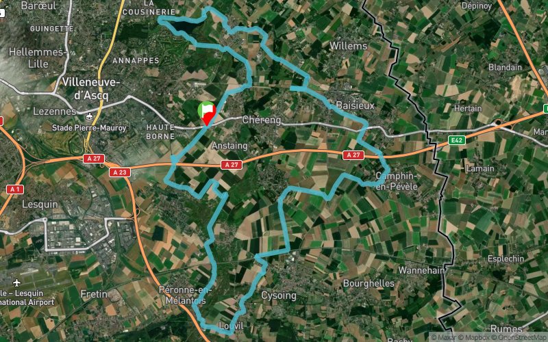


37.7 km
400 m
400 m
 Anstaing (59)
Variante de la trace "classique" De La Marque à l'Arbre en incluant un passage dans Louvil et dans le marais de Péronne où passe aussi la Marque.
Parcours sans difficulté, peu technique, praticable toute l'année en VTT ou à pied.
Majorité de chemins et sentiers. Des passages sur le bitume mais globalement aucune gène par la circulation.
Points of Interest table
| Accum. | Intermediary | |||||||
|---|---|---|---|---|---|---|---|---|
| POI | Description | Alt. | Dist. | D+ | D- | Dist. | D+ | D- |
Trace n°25493
Ascent threshold : 3 m Distance threshold : 30 m Smoothing : Yes Origin of altitudes : MNT Aster GDEM
Ascent threshold : 3 m Distance threshold : 30 m Smoothing : Yes Origin of altitudes : MNT Aster GDEM
Loop
Dominant terrain : Path
Max alti. : 55 m
Avg alti. : 27 m
Min alti. : 12 m
Longest ascent : 80 m
Longest descent : 90 m
Route completed by the author : Yes
Dominant terrain : Path
Max alti. : 55 m
Avg alti. : 27 m
Min alti. : 12 m
Longest ascent : 80 m
Longest descent : 90 m
Route completed by the author : Yes
Elevation profile
More tools
Create a new roadbook page
Map and track on your website
Warning ! When you insert a Trace de Trail map on your website, you agree not to hide any element of the module (links to Trail Trail or Trail Connect banner)
Add a realisation
Validate
Add a realisation to share your chrono and describe the conditions that you encountered during you trail running !
Add a comment
Validate
Show the infos
Add a track


