Show the map
Boucle au départ de Lons-le-Saunier
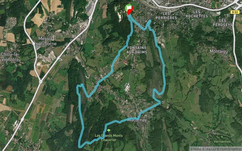


10.7 km
414 m
416 m
 Lons-le-Saunier (39)
 Points of Interest table
| Accum. | Intermediary | |||||||
|---|---|---|---|---|---|---|---|---|
| POI | Description | Alt. | Dist. | D+ | D- | Dist. | D+ | D- |
Trace n°2543
Ascent threshold : 0 m Distance threshold : 35 m Smoothing : Yes Origin of altitudes : MNT Aster GDEM
Ascent threshold : 0 m Distance threshold : 35 m Smoothing : Yes Origin of altitudes : MNT Aster GDEM
Loop
Dominant terrain : Footpath
Max alti. : 451 m
Avg alti. : 333 m
Min alti. : 250 m
Longest ascent : 210 m
Longest descent : 190 m
Route completed by the author : nc
Dominant terrain : Footpath
Max alti. : 451 m
Avg alti. : 333 m
Min alti. : 250 m
Longest ascent : 210 m
Longest descent : 190 m
Route completed by the author : nc
Elevation profile
More tools
Create a new roadbook page
Map and track on your website
Warning ! When you insert a Trace de Trail map on your website, you agree not to hide any element of the module (links to Trail Trail or Trail Connect banner)
Add a realisation
Validate
Add a realisation to share your chrono and describe the conditions that you encountered during you trail running !
Add a comment
Validate
Admin - Trace de Trail
20/04/14, 19:27:18
Bonjour,
Je me suis permis de renommer votre trace afin qu'elle soit plus facilement identifiable via les outils de recherche...
N'hésitez pas à ajouter une réalisation si vous voulez identifier une sortie en particulier (date, conditions, météo...)
20/04/14, 19:27:18
Bonjour,
Je me suis permis de renommer votre trace afin qu'elle soit plus facilement identifiable via les outils de recherche...
N'hésitez pas à ajouter une réalisation si vous voulez identifier une sortie en particulier (date, conditions, météo...)
Show the infos
Add a track


