
2nd Magura Ultramarathon 2016
ITRA
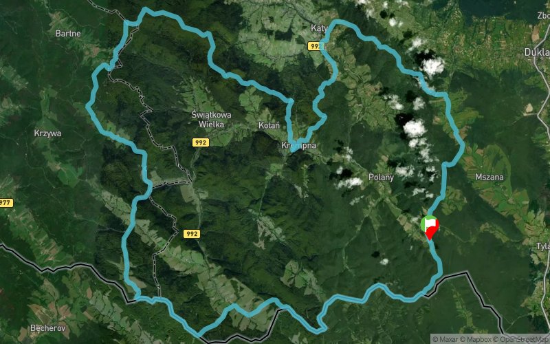
 92.3 km
2710 m
2710 m
92.3 km
2710 m
2710 m

GPX
8
PDF
Profile
Share
3D
Favorites
Reviews
Like
Šarbov (PL) (PL)
Effort kilometer
Longest ascent
Longest descent
119
350 m
400 m
Max. elevation
Min. elevation
Quality index
847 m
307 m
 1pt/11m
Idea Ultramaratonu Magurskiego zrodzi?a si? z pasji do biegania oraz mi?o?ci do górskich pejza?y i przyrody Beskidu Niskiego.
Pasmo Beskidu Niskiego znajduj?ce si? na uboczu g?ównych szlaków turystycznych oferuje wiele atrakcji cz?sto zapomnianych i tajemniczych. ?emkowskie chaty, pi?kne drewniane ko?cio?y i cerkwie, dzikie sady w nieistniej?cych wsiach a obok ukryte w trawach i lasach przedwojenne cmentarze.
To wszystko otoczone pi?kn? przyrod?, która na ka?dym kroku pokazuje, ?e nie bez powodu znaczne obszary masywów górskich obj?te zosta?y ochron? Parku Narodowego.
Krajobrazy te, przez wielu ludzi w Polsce jeszcze nie odkryte stanowi? tak?e ?wietne tereny do górskich biegów i wycieczek.
Ultramaraton Magurski to bieg zarówno dla do?wiadczonych zawodników jak i tych, którzy w biegach górskich stawiaj? dopiero pierwsze kroki.
En voir plus... En voir moins...

Start
Distance
0 km
Altitude
452 m
D+
0 m
D-
0 m
92.3 km
2710 m
2710 m
Finish
Distance
92.3 km
Altitude
452 m
D+
2710 m
D-
2710 m
Click on a point of interest to display it on the map
Reviews and times
Add a track
2nd Magura Ultramarathon 2016

Track number : 21015
Link to track :
https://tracedetrail.fr/en/trace/21015
Log in to insert this track on your website
 Trace de Trail