Show the map
Ronde des Mineurs 2016
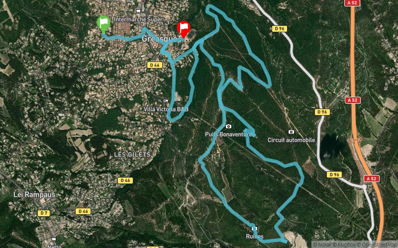


14.6 km
230 m
270 m
 Gréasque (13)
 Gréasque (13)
 Points of Interest table
| Accum. | Intermediary | |||||||
|---|---|---|---|---|---|---|---|---|
| POI | Description | Alt. | Dist. | D+ | D- | Dist. | D+ | D- |
 Competition organized on 02/28/2016
Trace n°19519
Ascent threshold : 3 m Distance threshold : 30 m Smoothing : Yes Origin of altitudes : MNT Aster GDEM
Ascent threshold : 3 m Distance threshold : 30 m Smoothing : Yes Origin of altitudes : MNT Aster GDEM
Crossing
Dominant terrain : Path
Max alti. : 382 m
Avg alti. : 325 m
Min alti. : 279 m
Longest ascent : 100 m
Longest descent : 100 m
Dominant terrain : Path
Max alti. : 382 m
Avg alti. : 325 m
Min alti. : 279 m
Longest ascent : 100 m
Longest descent : 100 m
Elevation profile
More tools
Create a new roadbook page
Map and track on your website
Warning ! When you insert a Trace de Trail map on your website, you agree not to hide any element of the module (links to Trail Trail or Trail Connect banner)
Add a realisation
Validate
Add a realisation to share your chrono and describe the conditions that you encountered during you trail running !
Add a comment
Validate
runcisco
19/03/16, 12:14:15
parcours exact de la course la ronde des mineurs. le départ et l'arrivée ne sont pas au même endroit. départ en descente sur bitume. arrivée en côte sur bitume. 2 ravitaillements.
19/03/16, 12:14:15
parcours exact de la course la ronde des mineurs. le départ et l'arrivée ne sont pas au même endroit. départ en descente sur bitume. arrivée en côte sur bitume. 2 ravitaillements.
Show the infos
Add a track


