Show the map
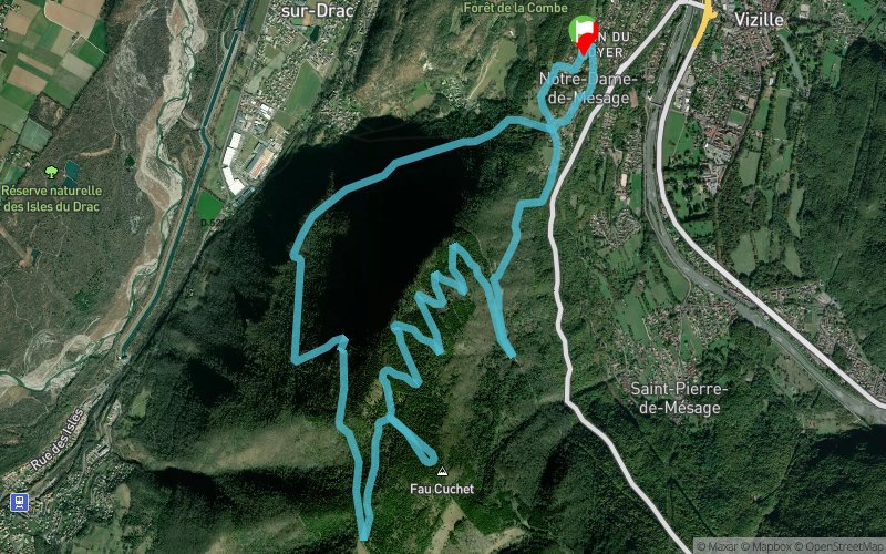
Beauplat - Fau Cuchet - Couvent des Moines Rouges


15.4 km
1000 m
1000 m

Points of Interest table
Accum. | Intermediary | |||||||
---|---|---|---|---|---|---|---|---|
POI | Description | Alt. | Dist. | D+ | D- | Dist. | D+ | D- |
Trace n°19220
Ascent threshold : 3 m Distance threshold : 30 m Smoothing : Yes Origin of altitudes : MNT Aster GDEM
Loop
Dominant terrain : Footpath
Max alti. : 1347 m
Avg alti. : 870 m
Min alti. : 431 m
Longest ascent : 930 m
Longest descent : 960 m
Route completed by the author : nc
Dominant terrain : Footpath
Max alti. : 1347 m
Avg alti. : 870 m
Min alti. : 431 m
Longest ascent : 930 m
Longest descent : 960 m
Route completed by the author : nc
Elevation profile

Their last tracks
Forêt de Versailles - Forêt de Meudon - Parc de St-Cloud - Bois de Boulogne
40.1 km
840 m
910 m
Versailles (78)
More tools
Create a new roadbook page
Carte à la Carte IGN
Map and track on your website
Warning ! When you insert a Trace de Trail map on your website, you agree not to hide any element of the module (links to Trail Trail or Trail Connect banner)
Add a realisation
Validate
Add a realisation to share your chrono and describe the conditions that you encountered during you trail running !
Add a comment
Validate
Nearby tracks
1.9 km Les Allas - Bois des Vignasses - Les Meynards - Le Grand Plan
13.7 km
610 m
610 m
Vizille (38)
2.0 km Forêt de Vizille - Les Corniers - Les Travers - Le Grand Plan
10.8 km
420 m
420 m
Vizille (38)
2.0 km Les Allas - Forêt de Vizille - Bois de Mont Sec - Les Corniers
14.3 km
970 m
970 m
Vizille (38)
2.0 km Lac Luitel - Col de la Vache - Col de Claran - Col de la Perrière - Montgilbert
125.3 km
10420 m
10390 m
Vizille (38)
Show the infos
Add a track