Show the map
Certified Track - ITRA
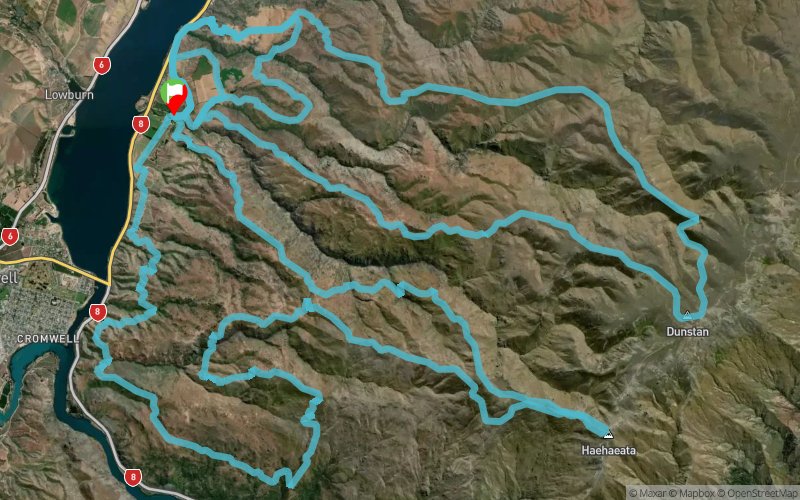
Northburn 100 Miler 2016 - 100 km


 Cromwell (NZ)


Yes! The 100k is all on for 2016!!
Click the maps below to view as Jpegs or down load the google earth files from the Route Profiles tab above. The 100k course covers 2 maps, each loop starts and finishes in the same place - great to catch up with your supporters!
The first 50km loop take you from 200m above sea level (Start/finish) up near the most central point in New Zealand at around 1660m (2600m vertical climb). The second 'loop' is another 50km loop with a climb of 3750m.
There will be plenty of marshals along key areas of the course. The course will be well marked with directional arrows, plastic poles and reflective tape at night.
There will be two aid stations with nutrition and electrolyte supplements, each one about half way around each loop. You will also be coming back through the start/finish area at the 50k mark you will be able to pick up your personal refreshments/gear as required. There will be multiple fresh water re-fill positions (creeks) along the course so a water carrying capacity of about 2L per person should be adequate there will be some compulsory re-fill points.
This is a dry, hard, rocky course mostly run over high country 4WD tracks but also including some short sections of fence lines and sheep tracks. The weather can be 'changeable' so your minimum gear must be carried at all times.
Points of Interest table
| Accum. | Intermediary | |||||||
|---|---|---|---|---|---|---|---|---|
| POI | Description | Alt. | Dist. | D+ | D- | Dist. | D+ | D- |
 Competition organized on 03/19/2016
Trace n°15218
Ascent threshold : 10 m Distance threshold : 0 m Smoothing : No Origin of altitudes : GPS
Ascent threshold : 10 m Distance threshold : 0 m Smoothing : No Origin of altitudes : GPS
Loop
Dominant terrain : Path
Max alti. : 1661 m
Avg alti. : 814 m
Min alti. : 149 m
Longest ascent : 1620 m
Longest descent : 1090 m
Dominant terrain : Path
Max alti. : 1661 m
Avg alti. : 814 m
Min alti. : 149 m
Longest ascent : 1620 m
Longest descent : 1090 m
Elevation profile
More tools
Create a new roadbook page
Map and track on your website
Warning ! When you insert a Trace de Trail map on your website, you agree not to hide any element of the module (links to Trail Trail or Trail Connect banner)
Add a realisation
Validate
Add a realisation to share your chrono and describe the conditions that you encountered during you trail running !
Add a comment
Validate
Show the infos
Add a track


