Show the map
Trail des Gets 2021 - Trail Rouge


 Les Gets (74)
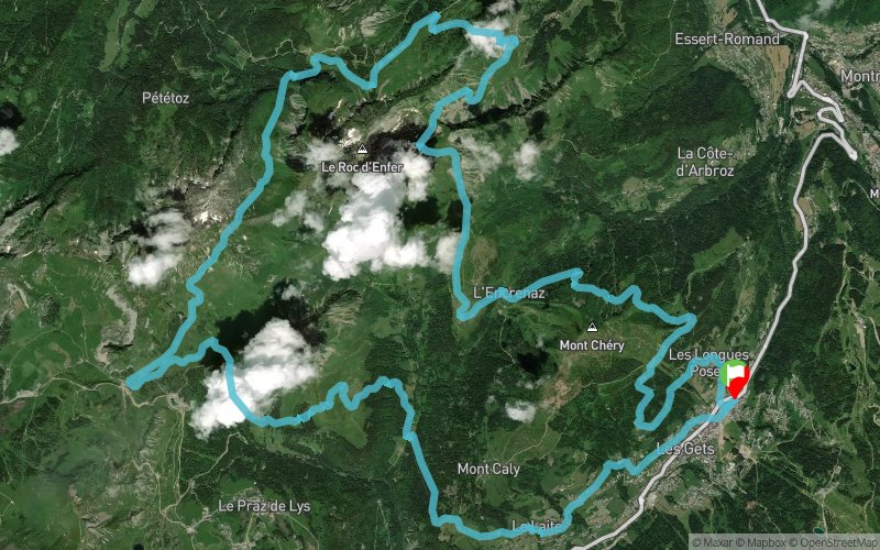
For the Trail des Gets large format, we propose you go around the Roc d’Enfer, a mythical, wild and impressive mountain.
Culminating at an altitude of 2224 m, it is one of the highest peaks in the Chablais mountain range. The Roc d’Enfer is home to an interesting fauna: golden eagles, roe deer and chamois. So don’t forget to keep an eye out!
This trail offers a very diversified route between mountain pasture crossings, forest tracks and technical single paths in the forest. You will also go through several passes: Col de la Ramaz, Col de Chalune, Col Ratti and Col de l’Encrenaz, at each stage discovering a new aspect of this exceptional mountain.
All along the course, enjoy exceptional panoramic views of the Aulps valley and the iconic peaks of the surrounding mountains: the Mont Blanc range, Aravis range, the Dents du Midi and some 4000 Swiss peaks.
Points of Interest table
| Accum. | Intermediary | |||||||
|---|---|---|---|---|---|---|---|---|
| POI | Description | Alt. | Dist. | D+ | D- | Dist. | D+ | D- |
 Competition organized on 07/18/2021
Trace n°151742
Ascent threshold : 3 m Distance threshold : 30 m Smoothing : Yes Origin of altitudes : MNT Aster GDEM
Ascent threshold : 3 m Distance threshold : 30 m Smoothing : Yes Origin of altitudes : MNT Aster GDEM
Loop
Dominant terrain : Path
Max alti. : 1907 m
Avg alti. : 1474 m
Min alti. : 1160 m
Longest ascent : 630 m
Longest descent : 540 m
Dominant terrain : Path
Max alti. : 1907 m
Avg alti. : 1474 m
Min alti. : 1160 m
Longest ascent : 630 m
Longest descent : 540 m
Elevation profile
More tools
Create a new roadbook page
Map and track on your website
Warning ! When you insert a Trace de Trail map on your website, you agree not to hide any element of the module (links to Trail Trail or Trail Connect banner)
Add a realisation
Validate
Add a realisation to share your chrono and describe the conditions that you encountered during you trail running !
Add a comment
Validate
Show the infos
Add a track


