Show the map
MTB Baisoara Mediu
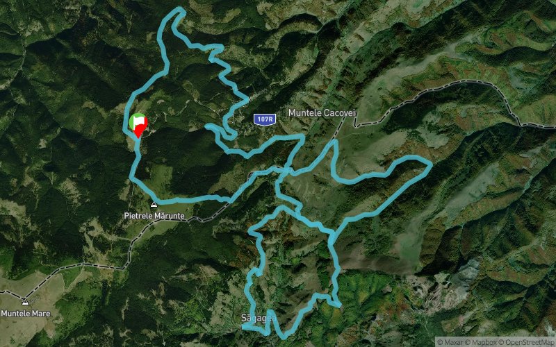


47 km
2210 m
2210 m
 Muntele Cacovei (RO)
Sesu Cald - Pietrele Marunte - Crucea Crencii - Stiolne - Poiana Romaneasa - Sagagea - dealul Ticu - Bocsesti - Stiolne - inconjor Muntele Boului - Zapodie - dealul Boinic - Crucea Crencii - Valea Vadului - Skiland - Montana - poiana Gabriana - fantana Gabrienii - poiana Buhuia - Sesu Cald
Points of Interest table
| Accum. | Intermediary | |||||||
|---|---|---|---|---|---|---|---|---|
| POI | Description | Alt. | Dist. | D+ | D- | Dist. | D+ | D- |
Trace n°124150
Ascent threshold : 3 m Distance threshold : 30 m Smoothing : No Origin of altitudes : MNT Aster GDEM
Ascent threshold : 3 m Distance threshold : 30 m Smoothing : No Origin of altitudes : MNT Aster GDEM
Loop
Dominant terrain : Path
Max alti. : 1713 m
Avg alti. : 1241 m
Min alti. : 803 m
Longest ascent : 370 m
Longest descent : 630 m
Route completed by the author : Yes
Dominant terrain : Path
Max alti. : 1713 m
Avg alti. : 1241 m
Min alti. : 803 m
Longest ascent : 370 m
Longest descent : 630 m
Route completed by the author : Yes
Elevation profile
More tools
Create a new roadbook page
Map and track on your website
Warning ! When you insert a Trace de Trail map on your website, you agree not to hide any element of the module (links to Trail Trail or Trail Connect banner)
Add a realisation
Validate
Add a realisation to share your chrono and describe the conditions that you encountered during you trail running !
Add a comment
Validate
Show the infos
Add a track


