The Oisans balconies
Add to my favorites

Caution! Zone of vigilance near the route
Faucon pèlerin - du 01/02/2024 au 30/06/2024 In progress
Faucon pèlerin - du 01/02/2024 au 30/06/2024 In progress
Circaète Jean-le-Blanc - du 01/03/2024 au 30/09/2024 In progress
Circaète Jean-le-Blanc - du 01/03/2024 au 30/09/2024 In progress
Circaète Jean-le-Blanc - du 01/03/2024 au 30/09/2024 In progress
Circaète Jean-le-Blanc - du 01/03/2024 au 30/09/2024 In progress
Aigle royal - du 01/01/2024 au 31/08/2024 In progress
Aigle royal - du 01/01/2024 au 31/08/2024 In progress

The Oisans balconies are a festival of high-perched roads, a hymn to panoramic views and a cluster of eagle’s nest lookout points. Oisans is under your wheels and under your gaze in a series of outstanding sporting moments. Impossible to leave off your “to do” list!
The characteristics of the route.

Le Bourg-d'Oisans (38)
- Distance 81.9 km
- Elevation gain 2630 m
- Elevation lost 2630 m
- Min. elevation 708 m
- Max. elevation. 1998 m
- Marking No
Itinerary no. 3 of the “Cycling in Oisans” guide (Oisans Tourisme)
Departure / Arrival: Bourg d’Oisans 720 m
Time: 6 h
Distance (R/T): 93 km
Highest point: 1999 m
Lowest point: 720 m
Total ascent: 3266 m
Max. gradient: 14%
Map: Michelin Local Map no. 333 Isère, Savoie
ITINERARY
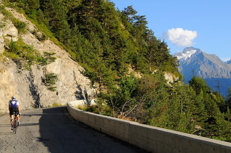
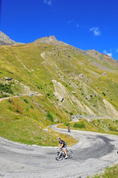
From Bourg-d'Oisans, follow signs for “Alpe d'Huez” to La Garde-en-Oisans. Turn right towards “Auris-en-Oisans” via the Route de la Roche, with its wonderful view over the plain. The show has started! Ride through the hamlets of Auris and back down to the valley to Le Freney. Turn right towards Bourg d'Oisans (D 1091), down 3.7 km to the third turning on the left (D220). Keep your eyes open as there are no signs for this narrow road that winds its way up through the forest, before opening out onto a balcony road to Mont-de-Lans.
Ride down and cross over the dam, before turning up left onto the road to Mizoën, a small village perched above the lake. Get ready for the climb up to the Col de Sarenne: 13 km and a height gain of 954 m, with an average gradient of 7.45%! A good workout for the legs, punctuated by fabulous view points right up to the top, made famous by the 2013 Tour de France.
The road then takes you up to Alpe d'Huez. Then ride down to Huez and turn right towards Villard-Reculas via the road known as the "Pas de la Confession".
Next, ride down towards Allemond. After a number of switchbacks, take the second road off to the right (signposted Le Boulangeard) and carry on along the narrow road to Oz-en-Oisans cemetery. Turn left to the Lac du Verney and ride along the lake shore before turning right, signposted “Le Rivier d’Allemond”. To ride round the lake, turn left 2 km after starting the climb, following signs for “Allemond Eglise”. The Route du Villaret takes you to the church, from where you drop back down onto the plain. Turn right and at Rochetaillé, take a left for a last enthusiastic bout of peddling to Bourg d'Oisans!
THAT LITTLE BIT FURTHER : 31 km, +1159 m
For a wonderful finale to the Oisans balconies join up with Route Villard Notre Dame and Villard Reymond.Admission fee : Free of charge.Opening : From 01/05 to 31/10. Subject to favorable snow and weather conditions.
Departure / Arrival: Bourg d’Oisans 720 m
Time: 6 h
Distance (R/T): 93 km
Highest point: 1999 m
Lowest point: 720 m
Total ascent: 3266 m
Max. gradient: 14%
Map: Michelin Local Map no. 333 Isère, Savoie
ITINERARY
From Bourg-d'Oisans, follow signs for “Alpe d'Huez” to La Garde-en-Oisans. Turn right towards “Auris-en-Oisans” via the Route de la Roche, with its wonderful view over the plain. The show has started! Ride through the hamlets of Auris and back down to the valley to Le Freney. Turn right towards Bourg d'Oisans (D 1091), down 3.7 km to the third turning on the left (D220). Keep your eyes open as there are no signs for this narrow road that winds its way up through the forest, before opening out onto a balcony road to Mont-de-Lans.
Ride down and cross over the dam, before turning up left onto the road to Mizoën, a small village perched above the lake. Get ready for the climb up to the Col de Sarenne: 13 km and a height gain of 954 m, with an average gradient of 7.45%! A good workout for the legs, punctuated by fabulous view points right up to the top, made famous by the 2013 Tour de France.
The road then takes you up to Alpe d'Huez. Then ride down to Huez and turn right towards Villard-Reculas via the road known as the "Pas de la Confession".
Next, ride down towards Allemond. After a number of switchbacks, take the second road off to the right (signposted Le Boulangeard) and carry on along the narrow road to Oz-en-Oisans cemetery. Turn left to the Lac du Verney and ride along the lake shore before turning right, signposted “Le Rivier d’Allemond”. To ride round the lake, turn left 2 km after starting the climb, following signs for “Allemond Eglise”. The Route du Villaret takes you to the church, from where you drop back down onto the plain. Turn right and at Rochetaillé, take a left for a last enthusiastic bout of peddling to Bourg d'Oisans!
THAT LITTLE BIT FURTHER : 31 km, +1159 m
For a wonderful finale to the Oisans balconies join up with Route Villard Notre Dame and Villard Reymond.Admission fee : Free of charge.Opening : From 01/05 to 31/10. Subject to favorable snow and weather conditions.
Area : Oisans
Report a problem Add a comment
Website Features of the application :
- Location and orientation on detailed maps thanks to the GPS of your smartphone
- Description of routes and points of interest on the route
- Photo gallery by route
- Detailed elevation profile
- Route tracking alert to warn you if you stray from the route
- Send predefined messages by SMS to your contacts
- Emergency module: trigger a call or send an emergency SMS in case of problem
- Agenda: access to events organized in the department
- News: find in the application the latest news on the web portal
- Adding achievements
- Add reports in case of problems encountered on the routes
- Share on social networks
Add your time and share your feelings
Services nearby

Tourist office of Le Bourg-d'Oisans
Le Bourg-d'Oisans

Museum of Minerals and Alpine Wildlife
Le Bourg-d'Oisans
Auris-en-Oisans tourist office
Auris-en-Oisans
Tourist office of Villard-Reculas
Villard-Reculas
Office de Tourisme
Alpe d'Huez


Information updated on 2024-03-18 by Oisans Tourisme


Follow us on
the digital trails
the digital trails


![]()
The Isère Outdoor application was created
by the Département de l'Isère
Infos & contact
Conseil départemental de l'Isère
7 rue Fantin Latour
CS 41096
38 022 Grenoble cedex 1
Tel. 04 76 00 38 38


OK
Annuler