Show the map
Le Buehl - Beschenberg - Grauersbeerg
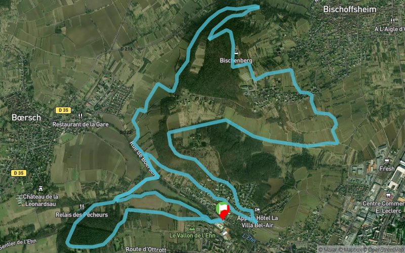


17.3 km
560 m
560 m
 Obernai (67)
 Points of Interest table
| Accum. | Intermediary | |||||||
|---|---|---|---|---|---|---|---|---|
| POI | Description | Alt. | Dist. | D+ | D- | Dist. | D+ | D- |
Trace n°111585
Ascent threshold : 3 m Distance threshold : 30 m Smoothing : No Origin of altitudes : MNT Aster GDEM
Ascent threshold : 3 m Distance threshold : 30 m Smoothing : No Origin of altitudes : MNT Aster GDEM
Loop
Dominant terrain : Path
Max alti. : 364 m
Avg alti. : 250 m
Min alti. : 186 m
Longest ascent : 150 m
Longest descent : 110 m
Route completed by the author : Yes
Dominant terrain : Path
Max alti. : 364 m
Avg alti. : 250 m
Min alti. : 186 m
Longest ascent : 150 m
Longest descent : 110 m
Route completed by the author : Yes
Elevation profile
More tools
Create a new roadbook page
Map and track on your website
Warning ! When you insert a Trace de Trail map on your website, you agree not to hide any element of the module (links to Trail Trail or Trail Connect banner)
Add a realisation
Validate
Add a realisation to share your chrono and describe the conditions that you encountered during you trail running !
Add a comment
Validate
Djay
06/01/22, 13:26:10
Merci pour ce parcours bien sympa, dommage que les 3 derniers km soit sur du bitume,
06/01/22, 13:26:10
Merci pour ce parcours bien sympa, dommage que les 3 derniers km soit sur du bitume,
Show the infos
Add a track


