Show the map
Le Rubi - Dôme de Barrot
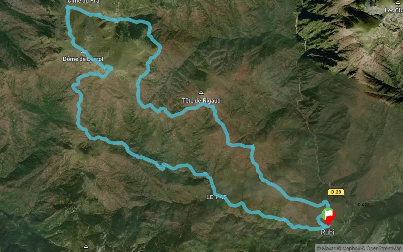


24.1 km
1899 m
1887 m
 Rigaud (06)
 Points of Interest table
| Accum. | Intermediary | |||||||
|---|---|---|---|---|---|---|---|---|
| POI | Description | Alt. | Dist. | D+ | D- | Dist. | D+ | D- |
Trace n°10911
Ascent threshold : 3 m Distance threshold : 30 m Smoothing : Yes Origin of altitudes : MNT Aster GDEM
Ascent threshold : 3 m Distance threshold : 30 m Smoothing : Yes Origin of altitudes : MNT Aster GDEM
Loop
Dominant terrain : Footpath
Max alti. : 2120 m
Avg alti. : 1463 m
Min alti. : 757 m
Longest ascent : 1151 m
Longest descent : 1518 m
Route completed by the author : nc
Dominant terrain : Footpath
Max alti. : 2120 m
Avg alti. : 1463 m
Min alti. : 757 m
Longest ascent : 1151 m
Longest descent : 1518 m
Route completed by the author : nc
Elevation profile
More tools
Create a new roadbook page
Map and track on your website
Warning ! When you insert a Trace de Trail map on your website, you agree not to hide any element of the module (links to Trail Trail or Trail Connect banner)
Add a realisation
Validate
Add a realisation to share your chrono and describe the conditions that you encountered during you trail running !
Add a comment
Validate
tomraptor06
26/08/15, 22:43:45
c'est un très beau parcours mais à faire plutôt vers octobre ou mai/juin (selon enneigement) car la partie finale plein sud est longue et s'il fait chaud c'est peu agréable
26/08/15, 22:43:45
c'est un très beau parcours mais à faire plutôt vers octobre ou mai/juin (selon enneigement) car la partie finale plein sud est longue et s'il fait chaud c'est peu agréable
Show the infos
Add a track


