Show the map
La Cros d'Utelle - Madone d'Utelle - Collet d'Huesti
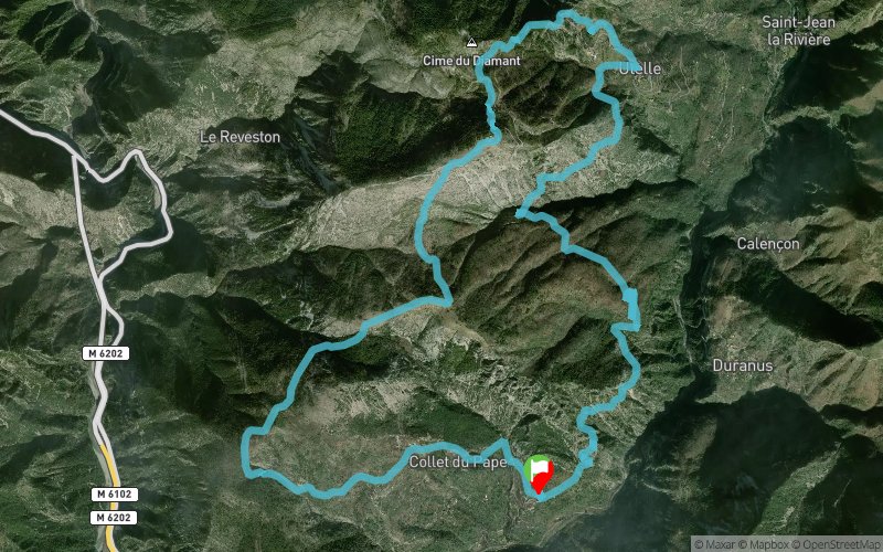


19.4 km
1274 m
1271 m
 Duranus (06)
 0 (0)
0 (0) Points of Interest table
| Accum. | Intermediary | |||||||
|---|---|---|---|---|---|---|---|---|
| POI | Description | Alt. | Dist. | D+ | D- | Dist. | D+ | D- |
Trace n°10785
Ascent threshold : 3 m Distance threshold : 30 m Smoothing : Yes Origin of altitudes : MNT Aster GDEM
Ascent threshold : 3 m Distance threshold : 30 m Smoothing : Yes Origin of altitudes : MNT Aster GDEM
Crossing
Dominant terrain : Footpath
Max alti. : 1174 m
Avg alti. : 784 m
Min alti. : 347 m
Longest ascent : 409 m
Longest descent : 442 m
Route completed by the author : nc
Dominant terrain : Footpath
Max alti. : 1174 m
Avg alti. : 784 m
Min alti. : 347 m
Longest ascent : 409 m
Longest descent : 442 m
Route completed by the author : nc
Elevation profile
More tools
Create a new roadbook page
Map and track on your website
Warning ! When you insert a Trace de Trail map on your website, you agree not to hide any element of the module (links to Trail Trail or Trail Connect banner)
Add a realisation
Validate
Add a realisation to share your chrono and describe the conditions that you encountered during you trail running !
Add a comment
Validate
tomraptor06
25/08/15, 18:08:46
merci beaucoup pour la modif, effectivement je suis pas très fort en informatique mais j'aime faire partager ma passion, donc encore merci... N’hésitez pas à faire les modif si nécessaire...
25/08/15, 18:08:46
merci beaucoup pour la modif, effectivement je suis pas très fort en informatique mais j'aime faire partager ma passion, donc encore merci... N’hésitez pas à faire les modif si nécessaire...
Admin - Trace de Trail
21/08/15, 22:24:51
Bonjour, C'est normal, votre tracé faisait deux fois la boucle... C'est corrigé. Bon trail !
21/08/15, 22:24:51
Bonjour, C'est normal, votre tracé faisait deux fois la boucle... C'est corrigé. Bon trail !
More comments
tomraptor06
21/08/15, 22:17:43
le tracé fait en fait ma moitié en distance que celle affichée, c'est à dire 19,4 km et meme chose pur le dénivellé. c'est un tour très sympa à faire en 2h30 environ
21/08/15, 22:17:43
le tracé fait en fait ma moitié en distance que celle affichée, c'est à dire 19,4 km et meme chose pur le dénivellé. c'est un tour très sympa à faire en 2h30 environ
Show the infos
Add a track


