Show the map
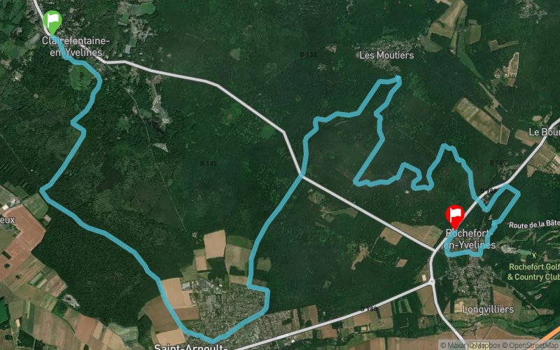
La Diagonale des Yvelines 2020 - 20 km


20.7 km
260 m
280 m


Points of Interest table
Accum. | Intermediary | |||||||
---|---|---|---|---|---|---|---|---|
POI | Description | Alt. | Dist. | D+ | D- | Dist. | D+ | D- |

Trace n°102365
Ascent threshold : 3 m Distance threshold : 30 m Smoothing : Yes Origin of altitudes : MNT IGN
Crossing
Dominant terrain : Footpath
Max alti. : 169 m
Avg alti. : 130 m
Min alti. : 98 m
Longest ascent : 60 m
Longest descent : 50 m
Dominant terrain : Footpath
Max alti. : 169 m
Avg alti. : 130 m
Min alti. : 98 m
Longest ascent : 60 m
Longest descent : 50 m
Elevation profile

Their last tracks
More tools
Create a new roadbook page
Carte à la Carte IGN
Map and track on your website
Warning ! When you insert a Trace de Trail map on your website, you agree not to hide any element of the module (links to Trail Trail or Trail Connect banner)
Add a realisation
Validate
Add a realisation to share your chrono and describe the conditions that you encountered during you trail running !
Add a comment
Validate
Nearby tracks
9.3 km Bois des Vindrins - Chevreuse - Vaux de Cernay - Étang de la Tour
50.3 km
680 m
680 m
Rambouillet (78)
10.2 km St Léger en Yvelines - Gambaiseuil - Poigny-la-Forêt - Gazeran
53 km
790 m
790 m
Rambouillet (78)
10.5 km La Diagonale des Yvelines 2019 - Diag78 - Ultra
89.5 km
1080 m
1170 m
Rochefort-en-Yvelines (78)
10.7 km Bois d'Aumont - Le Bourgneuf - Moûtiers - Forêt de Ronqueux
11.6 km
260 m
260 m
Bullion (78)
11.4 km Vaux de Cernay - Etang de l'Abbaye - Pont de Grandvat
19.4 km
538 m
541 m
Cernay-la-Ville (78)
11.4 km Etang de Cernay - Vaux de Cernay - Etang de l'Abbaye
13.2 km
449 m
451 m
Cernay-la-Ville (78)
Show the infos
Add a track