Show the map
Seyssinet-Pariset - St-Nizier-de-Moucherotte - Les Arcelles - La Tour sans Venin
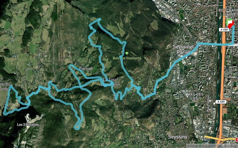


27.6 km
1260 m
1260 m
 Seyssinet-Pariset (38)
 Points of Interest table
| Accum. | Intermediary | |||||||
|---|---|---|---|---|---|---|---|---|
| POI | Description | Alt. | Dist. | D+ | D- | Dist. | D+ | D- |
Trace n°68594
Ascent threshold : 3 m Distance threshold : 30 m Smoothing : No Origin of altitudes : MNT Aster GDEM
Ascent threshold : 3 m Distance threshold : 30 m Smoothing : No Origin of altitudes : MNT Aster GDEM
Loop
Dominant terrain : Footpath
Max alti. : 1275 m
Avg alti. : 636 m
Min alti. : 209 m
Longest ascent : 1050 m
Longest descent : 1240 m
Route completed by the author : Yes
Dominant terrain : Footpath
Max alti. : 1275 m
Avg alti. : 636 m
Min alti. : 209 m
Longest ascent : 1050 m
Longest descent : 1240 m
Route completed by the author : Yes
Elevation profile
More tools
Create a new roadbook page
Map and track on your website
Warning ! When you insert a Trace de Trail map on your website, you agree not to hide any element of the module (links to Trail Trail or Trail Connect banner)
Add a realisation
Validate
Add a realisation to share your chrono and describe the conditions that you encountered during you trail running !
Add a comment
Validate
Mika-Marie
21/09/18, 17:57:54
Belle montée avec une bonne série de marches en arrivant sous le tremplin. Descente technique à deux - trois endroits. Point eau aux Vouillands à prendre en considération si il fait chaud.
21/09/18, 17:57:54
Belle montée avec une bonne série de marches en arrivant sous le tremplin. Descente technique à deux - trois endroits. Point eau aux Vouillands à prendre en considération si il fait chaud.
Show the infos
Add a track


