Show the map
Certified Track - ITRA
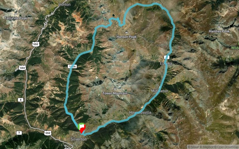
Silverton Alpine Marathon & 50K 2017 - Alpine 50K


 Silverton (US)


50 Kilometer and Marathon (~26.7 Mile) loop in the San Juan Mountains of Colorado. The course follows the “Alpine Loop” jeep roads past the ghost mining towns of Howardsville, Eureka, Animas Forks and Gladstone. High point is California Pass at 12,930 feet!
Points of Interest table
| Accum. | Intermediary | |||||||
|---|---|---|---|---|---|---|---|---|
| POI | Description | Alt. | Dist. | D+ | D- | Dist. | D+ | D- |
 Competition organized on 08/19/2017
Trace n°32453
Ascent threshold : 10 m Distance threshold : 0 m Smoothing : No Origin of altitudes : GPS
Ascent threshold : 10 m Distance threshold : 0 m Smoothing : No Origin of altitudes : GPS
Loop
Dominant terrain : Path
Max alti. : 3933 m
Avg alti. : 3165 m
Min alti. : 2839 m
Longest ascent : 1170 m
Longest descent : 1070 m
Dominant terrain : Path
Max alti. : 3933 m
Avg alti. : 3165 m
Min alti. : 2839 m
Longest ascent : 1170 m
Longest descent : 1070 m
Elevation profile
More tools
Create a new roadbook page
Map and track on your website
Warning ! When you insert a Trace de Trail map on your website, you agree not to hide any element of the module (links to Trail Trail or Trail Connect banner)
Add a realisation
Validate
Add a realisation to share your chrono and describe the conditions that you encountered during you trail running !
Add a comment
Validate
Show the infos
Add a track


