Show the map
Evaluated Track - ITRA
Table Mountain Challenge 2017 - 44 km
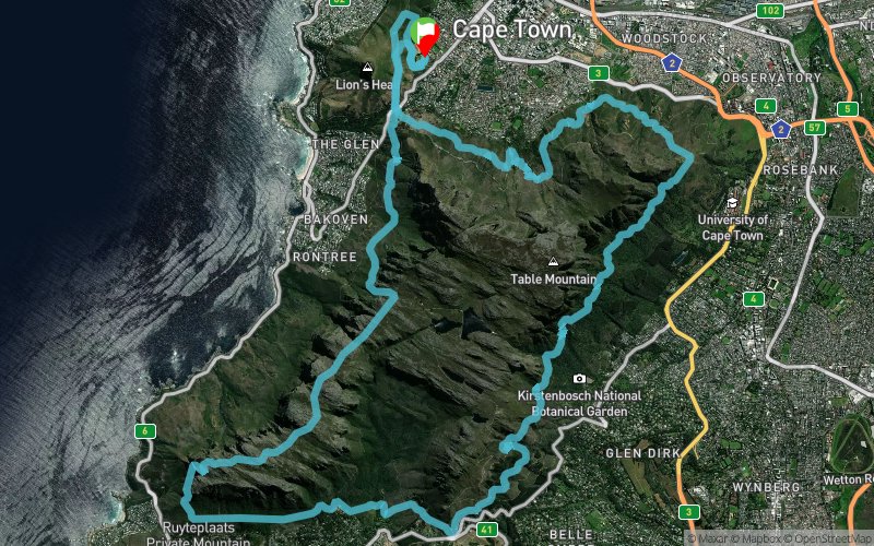


 Cape Town (ZA)


Points of Interest table
| Accum. | Intermediary | |||||||
|---|---|---|---|---|---|---|---|---|
| POI | Description | Alt. | Dist. | D+ | D- | Dist. | D+ | D- |
 Competition organized on 09/03/2017
Trace n°31978
Ascent threshold : 3 m Distance threshold : 30 m Smoothing : Yes Origin of altitudes : MNT Aster GDEM
Ascent threshold : 3 m Distance threshold : 30 m Smoothing : Yes Origin of altitudes : MNT Aster GDEM
Loop
Dominant terrain : Path
Max alti. : 742 m
Avg alti. : 346 m
Min alti. : 100 m
Longest ascent : 620 m
Longest descent : 730 m
Dominant terrain : Path
Max alti. : 742 m
Avg alti. : 346 m
Min alti. : 100 m
Longest ascent : 620 m
Longest descent : 730 m
Elevation profile
More tools
Create a new roadbook page
Map and track on your website
Warning ! When you insert a Trace de Trail map on your website, you agree not to hide any element of the module (links to Trail Trail or Trail Connect banner)
Add a realisation
Validate
Add a realisation to share your chrono and describe the conditions that you encountered during you trail running !
Add a comment
Validate
Stingrei
25/06/17, 20:13:07
The gpx track once downlaoded and opened doesnt look like the actual map of the route - I think the gpx is an old previous year race route. Comments?
25/06/17, 20:13:07
The gpx track once downlaoded and opened doesnt look like the actual map of the route - I think the gpx is an old previous year race route. Comments?
Show the infos
Add a track


